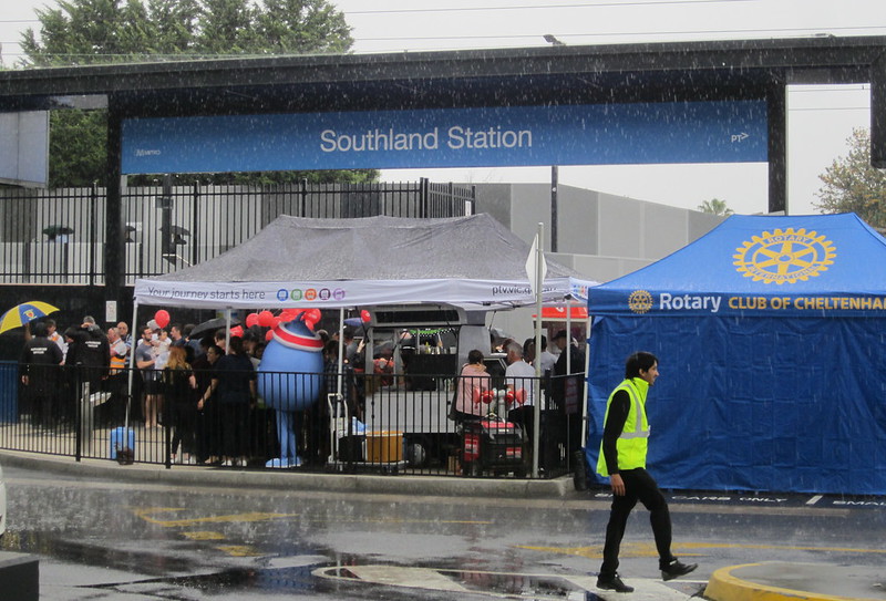
Happy (late) 5th birthday to Southland station! It’s five years last Saturday (election day) since the station finally opened, after having been promised during the 2010 election.
Some people actually believed that few people would use the station once it opened. This has proven to be completely wrong.
I thought I’d try to chart patronage at the various Frankston line stations south of Caulfield, before and after Southland station opened in 2017.
Patronage numbers have been pretty rocky during and post-COVID-19, making direct comparisons difficult. So instead I’ve tried charting the ranking of each station by patronage – from Glenhuntly to Frankston, excluding the inner section where all stations share (or previously shared) some patronage with other lines.
As you can see, Frankston has consistently been the busiest station on the line.
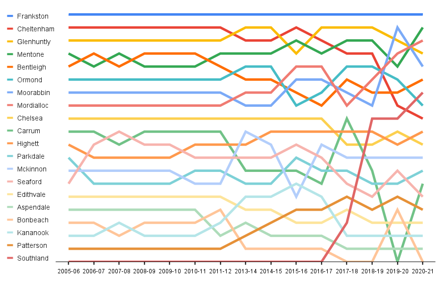
Since opening in November 2017, Southland has shot up the rankings to 7th busiest out of 20 for patronage. And that’s just the data to the end of the 2020-21 financial year, so that’s pretty good going for under 4 years – and covering some lockdown periods when people couldn’t go to most shops.
Stations like Southland are good for the rail network because they help diversify the trips on it. Pre-COVID this was important because it grew patronage without adding peak hour crowding. Post-COVID it’s important because many people no longer commute to 9-5 CBD office jobs.
Other things I notice in the chart:
- Most of the rankings are very consistent from about 2005 to 2012 – even though we know at this time that patronage right across the network was rising fast.
- As Southland has risen up the rankings, nearby Cheltenham has dropped. But are these directly related? Did lots of people actually walk from Cheltenham before Southland opened? I doubt it.
- EDIT: Some people have commented that they did indeed walk from Cheltenham to Southland – so did I, sometimes. But I submit that far fewer did than use Southland station now.
- I suspect Cheltenham’s patronage was affected more by extended closures during the level crossing removal project there.
- We’ll see if in time patronage at Cheltenham bounces back, but the other factor might be a long-term shift in commuting patterns due to COVID, possibly affecting some stations more than others. Hard to measure from a chart like this, I suspect.
- Other stations also saw big drops during their level crossing removal closures, for instance Ormond, McKinnon and Bentleigh during 2015-16
- Carrum shot up in 2017-18 (perhaps due to the Seaford project?), then down in 2019-20 (when its crossing project was done).
- Moorabbin shot up in 2019-20. This has been an important bus/train interchange point during bus replacements for works.
- Mentone has been consistently high, probably thanks to school traffic
- Patterson (which is just outside zone 1) was the least used station on the line for years, before moving up the rankings around the time of the zone 1+2 fare cut in 2015 – something I’ve written about before.
What else can you see?
Are there other lines that would benefit from this type of chart?
Source: DOT Annual metropolitan train station patronage (station entries) and earlier similar publications.
19 replies on “Southland station patronage”
“Moorabbin … has been an important bus/train interchange point during bus replacements for works.”
Like this weekend (3-4 Dec). Brighton Beach station is plastered with signs to direct Frankston bound passengers onto buses to take them up South Rd to Moorabbin station.
PS I love your chart, although it took me find Southland line. I wouldn’t mind a t-shirt with that graphic printed on it!
One of the problems with Southland Station was the absence of effective marketing and promotion for the station when it opened. There was strong awareness of the station through media, but there wasn’t an effort to really change behaviour in the short term through short term free travel offers (particularly in the lead up to Xmas), marketing by Southland along the line, posters, etc. It’s no great secret that Southland didn’t want the station for many years. I’m curious if anyone has seen any marketing or comms from them promoting it. You’d think Southland would be really pushing rail in the lead up to Xmas to avoid car parking congestion; or pushing messages like “if you’re coming home from the city by train then stop off to shop at Southland”.
Carrum and Seaford patronage are definitely linked. I know when they start doing Seaford again (ugh, why?) I’ll go to Carrum instead of trying to navigate a construction zone.
There’s a very good cycling and walking path between them now, and you don’t have to cross any streets or Nepean Hwy to make that trip, so it’ll be very easy for one to take up ridership from the other.
Interesting to see the patronage being so strong at Southland despite there still being no access from the western side of the railway line, which is a substantial residential area. A property has been purchased on Tulip Grove to allow access to an underpass, but I’m told by a friend who lives in this area the locals are resisting having it built because they fear the streets being clogged with commuter car parking. Short-sighted in my opinion, especially as the whole area is quite hard to get into from bigger roads like Bay Road and Jack Road, and also hard to get out of to access the station on foot or bike.
I used to always walk from Cheltenham to Southland Shopping centre when I lived on the Frankston line!
Southland has leapt up but is still performing worse than it should be. It should be ranked 3 or 4, not 7. Factors retarding usage include a. Lack of a direct western entrance (there was some local opposition), b. lack of reform to the bus network (including a direct Bay Rd route to Sandringham with stops near the station) and c. Atrociously bad design with no shelter on Platform 2 near the entrance (it was obviously a CBD-centric commuter station plonked at a location where this is not its dominant use). Plus the poor marketing that Adrian mentioned above. Fortunately all are fixable but only if DoT management adopts a patronage growth mindset.
As well as the rise of Moorabbin has been the rise of Mordialloc for similar reasons of substitute buses terminating there. Also notable is the relative decline of station usage between Aspendale and Kananook. Not only due to occupations (it’s been quite an unstable service) but also potentially due to competition from the new Mordialloc Freeway. Areas like Chelsea Heights and Aspendale Gardens often have poor east-west bus and active transport connections to the train but good car access to the freeway.
Southland Station is a 5 minute walk for me. I don’t use it when I am coming home in dark. Walking alone through the Southland car park to get to Bay Road puts me on high alert due to the access to Bay Rd being though a very quiet car park that has pockets of no visibility to anyone. This would change if PSOs were present in the area.or car parking was free for commuters
@Ross, it looks like the council made the area immediately to the west of the station a 4-hour parking zone, so problem solved. No reason not to provide direct access to the station and the shopping centre via Tulip Grove.
@Peter, it’ll be interesting to see the 2021-22 figures, and how the “new normal” looks with patronage.
I obtained the below annual station use figures from the data Daniel used for the charts. The decline is alarming, and unless a 100% recovery occurs in next few years the SRLA investment cannot be justified. SRLA 2035 forecast 17,300 per day cross to/from Southland and 10,900 use Southland even if SRLA is not built.
Of course 23 times the current use is not impossible with one entrance through Southland car park. The Pennydale cohort, Bayside Council and Minister Allan have blocked any entrance to Southland from the western side, and opposed the strategic cycling path connecting from Cheltenham to Southland over Bay Road to Highett for 6 years. The Inquiry Advisory Committee has shown the folly of this and it will be unsurprising to see SRLA abandoned.
Station name 2009-10 2017-18 2018-19 2019-20 2020-21 2020-21 Per Day Growth/Decline Growth/Decline (%)
Cheltenham 1402814 903699 823400 454850 233800 750 -589600 -1
Southland 0 300,167 557,650 441,650 277,000 750 -280,650 -50%
Highett 492723 520791 508400 328050 194000 600 -314400 -61.84%
Moorabbin 736517 744514 717700 671250 300700 -417000 -58.10%
Fraser Gibson
I think there was reasonable patronage by teens to cheltenham, who then walked to Southland SC before the Southland station opened. They probably did the short run from Mentone to Cheltenham after school. I remember a trader being worried about the loss of shoppers buying food and drink as they walked through Cheltenham, before Southland station opening. However I suspect few of the student cohort actually validated a ticket and would appear in Daniel’s data if it was based upon validations.
Now I have a teen I know they, with friends, often take the train from Mentone to Southland after school.
Southland station has obviously been a success, although to reach its full potential it really needs a western entrance and better bus connections, as well as extra shelter and better promotion.
In the medium term SRL will almost certainly make it the busiest station on the line, and at that point there should be serious consideration of relocating the platforms to the north of the subway, providing a shorter connection to the SRL station, an expanded station catchment, and hopefully better bus connections. Ideally you’d also replace that mess of a car park with a more human-friendly entry plaza and facade, but good luck convincing Westfield to get rid of car parking spaces.
The rest of the data is also pretty interesting; I’m surprised that 6 of the top 10 are stations that get skipped in peak, although it probably helps keep loadings balanced. As for Aspendale-Kananook, I don’t think their drop is really anything to do with them. Excluding Southland and the impact of works at Carrum, those four plus Patterson have more or less held steady as the five quietest stations, and their decline relative to Patterson is more a result of Patterson rising post-fare cut (with the mirror effect clearly visible at Bentleigh!). The actual stats might prove me wrong, but I think their decline is relative, not absolute, and more a product of developments elsewhere.
Curious why Carrum patronage fell around 2013 after only a minor dip in 2007 when Zone 2 was extended to Frankston. A switch to Seaford (similar to the Patterson effect) can be noted though
Carrum’s 6-month closure in 2019 can be seen with the equivalent rise at nearby Bonbeach (mix of people travelling up the line by various means and those using the shuttle bus connection)
A rise after the higher density apartments around Highett can also be noted, without the big drop that Cheltenham suffered when Southland
Another factor for Cheltenham’s drop would have been been park+ride patronage (from Beaumaris) moving to the Sandringham Line after the prolonged closure of the parking during the early works phase in 2019 pre-COVID. Some spaces are now kerbside parking stretching 800m from the station along Edward St (with CCTV monitoring)
Given multiple bus routes connect Cheltenham and Southland SC, some of the passengers using the train to get to Southland before Southand Station opened would have been using buses between Cheltenham and Southland.
The new Cheltenham Station has all platforms connected by a concourse, so passengers backtracking to/from stations further in to get express trains no longer have any reason to touch on and off at Cheltenham (although many of them would not have anyway) and that may have flowed through to the patronage calculations.
The above inflation fare hikes and/or Peninsular Link seem to have reduced zone 2 only to/from Frankston patronage about 10 years ago.
There used to be a few people who would get off the train at Cheltenham and get one of the buses to Southland, who would have migrated to using the station at Southland and account for some of the patronage loss at Cheltenham. I did it myself a fair few times
My table of Cheltenham, Southland, Highett comparison and 2021 figures was a mess ,so another try below
The 2020-21 decline is 50 to 100% there is a decline across the network and Brisbane, Sydney etc, however Melbourne has the greatest. Some recovery post Covid, however my observations on these stations is it is nothing like the 2009-2018 figures used to justify Level Crossing removal and now SRLA. The shift to cars and work at home etc throws the whole SRLA $36Bn into the “poor investment” Bin. SRLA show a double lane wide pedestrian /Cycle bridge from Scentre Group Car park in front of the station over Bay Road with escalators down into to SRLA below ground trains. Its 300m in the open, and will require swipe out swipe in. The figure forecast by SRLA EES business case is 17,300 transferring in 2035, and 10,900 on/off Southland if SRLA does not proceed. Scentre Group are “very difficult commercially” said an SRLA rep. as they were, and still are, about entry to Southland through their car park. Unless we see spectacular recovery of patronage 2021-22 and beyond the SRLA commencement station is not justified. It provides nothing but traffic congestion and pollution for Bayside Chelt. & Highett, as we have no pedestrian or cycling access on entry to Southland station. Kingston will go public soon with their cycle and pedestrian paths accesing Chelt,Southland ,SRLA and Highett. Bayside made no submission to SRLA and no pathways or station access plan to date.
2009-10 2017-18 2018-19 2019-20 2020-21 2020-21 Per Day Growth/ Decline %
Cheltenham 1402814 903699 823400 454850 233,800 750 -589600
Southland 0 300,167 557,650 441,650 277,000 750 – 280,650 -50%
Highett 492723 520791 508400 328050 194000 600 -314400 -61.80%
Moorrabin 736517 744514 717700 671250 300700 -417000 -58%
Fraser, yes unfortunately tables don’t work in the comments.
What’s interesting is that patronage recovery genuinely is a mix.
CBD commuting has not come back. It’s still well below 2019 levels. But recent data I’ve seen shows that most other types of trips have come back: weekend, evening, and suburban and regional (non-Melbourne commuter) trips.
On this basis it’s hard to say patronage drops have made SRL unviable. Arguably the recovery has been on the types of journeys that the SRL would serve well.
“Did lots of people actually walk from Cheltenham before Southland opened? I doubt it.”
Probably not many, but if you’re coming from the south via PT then your only option was to disembark at Cheltenham and get a bus or to walk. I would do this myself, check to see if a bus was coming and, if not, continue on foot.
There may have been a route via Mentone or Mordialloc but as I recall Cheltenham had better frequency to Southland so it was always better to disembark there.
There seems to be as lot of confusion and misrepresentation regarding Southland station and its access and connections, so let me have a shot at rectifying this.
– Scentre group have not said no tho this station in the past. They have always wanted it. The issue was always where it would go (originally on the North side of Bay Road, then straddling the bridge, and finally in the shopping centre carpark) and then how much space the government wanted for car parking at the station, all which would have had to have come from their parking numbers. Since both major parties went to the election stating they would build the station, Scentre group had no option but to lodge their counter offers to the Government to rectify these issues.
– Regarding a Western access. A block of land was NOT purchased to open up a Western access point. The block in question – 60 Tulip Grove – just happened to be up for sale at the time of planning for the station and PTV purchased the block as an access point for the construction of the station and, because of the purchase, a possible western entry point to the station. The initial plans prior to the purchase of 60 Tulip Grove did NOT show a western entry.
– Contrary to comments above, the reason the western entry was not built or opened was NOT SOLEY because the residents, Bayside Council and PTV / DoT did not want the entrance opened (89% of all participants in the public survey held between March – May 2015 said they did not want it opened), but also because A) The station was being designed and built as a RETAIL station specifically for shopping and activities at Southland Shopping Centre and NOT a residential passenger station and B) the expected number of residential users of the station was considered (and still is) MINIMAL overall as the station was to be built with platform access to the Shopping centre as its priority function and the neighbouring Cheltenham Station was (and is) the primary station for the local Pennydale and Mirvac residents as Cheltenham is a Premium Station, has express trains, has coffee shops, a newsagent, free parking, restaurants, Services Australia office (Medicare. etc), Doctors and Dentist services etc all within 2 mins walk of the station, NONE of which Southland has outside of mall opening hours and was not (and still has not) got. Further, one of the main reasons that ALL parties opposed the Western Entrance as mentioned above is traffic and parking issues with Tulip Grove being a dead end street of parking on both sides of the road and a SINGLE TRAFFICABLE LANE its entire length with a long hill and curve at the bottom and ALL parties considered this to be dangerous and unnecessary in the end as Southland carpark allows direct access to the station entrance directly in front of it and to both sides of the entryway only approx 150m by car from the Bay Road car park entry and immediate exit the same way whereas access via Tulip Grove requires almost 690m from Park Road and a further 120m to the nearest place to do a U-turn (Siede Court, which with this amount of traffic was considered by all parties to be unsafe) and then a further 800m to return to Park road, or, via Bay road through 5 internal residential roads a distance of 1.1km to the station entrance plus 150m to Siede court for a total of 2.5km back to Bay road. As you can see, it is not only dangerous and congested through internal residential streets, but totally unnecessary and silly. As well as the traffic issues, the local residents as well as Bayside Council considered the opening to also create of lowering of their amenity due to increased numbers of people walking through the area not necessarily needing to be there (IE not residents, not rail patrons going to and from car parking), a concern about an increase in crime (something that HAS occurred at Southland Shopping Centre since the station opening and generally does occur at any major shopping centre that gets connected to a new rail station), plus others had issues with noise and possible drunken behaviour form increased pedestrian access that would not otherwise occur or need to occur. It should also be noted that according to the official PTV Community and stakeholder feedback summary report dated Feb 16 2016, whilst the feedback on the station and its possible Western entrance was mainly residents with27.8% from Tulip Grove and 10.9% from adjacent to Tulip Grove, there were also 39.8% local community members and 12.8% of just broader community members, plus 4.5% from Heather Grove (Bayside) and 2.6% from Jean Street (Kingston) with 1.1% being from Government and 0.4% being from internet groups (The Pennydale Residents Action Group) and Scentre Group (Southland). ALL of these feedback items were taken into consideration before the decision was made BY PTV and DoT NOT to open the Western entrance.
– Public Transport Victoria spokesman Jake McLaughlan said in February 2016 that the property at 60 Tulip Grove could become an additional station entry, but that “This option will be reviewed in the long-term should there be a need for another access point as the density of the local area and demand for public transport services grows.”. It should be noted that since so much money (hundreds of Millions of Dollars) has been spent on Cheltenham Station for its rebuild and trenching to remove the level crossings at Park Road and Charman Road and post covid figures as well as the overwhelming majority of rail travel by local Pennydale and Mirvac residents continuing to use Cheltenham over Southland for the reasons specified above, PTV have advised that they are NOT likely to look at the opening of the western entry any time soon or in the mid term period either.
– Also with respect to comments above, neither the Pennydale Residents, Bayside council or the Minister of Transport have opposed the Strategic Cycling Path Connecting Cheltenham and Southland Stations and over Bay road to eventually connect to Highett Station. In fact it was the Pennydale residents who suggested this option to Bayside council and PTV and Victrack as part of the Pennydale Structure Planning Process in early 2017 as well as the continuation of that path along the rail corridor through Sir William Fry Reserve to Highett with a Tunnel underneath the tracks to link the Reserve and the path to Lyle Anderson Reserve in Highett at the same time. Whilst Bayside council decided not to proceed with the Pennydale structure plan in the end, the exact same thing has been pushed through Council since and continued to do as through submissions to the Suburban Rail Loop EES as well via community membership to the Precinct Reference Group process.
– Car parking restrictions were introduced by both Bayside Council and Kingston Council in areas close to Southland station and Southland shopping Centre to prevent spill over parking from Rail patrons who were being locked out of Southland Shopping Centre car parking due to Scentre group introducing paid car parking at the centre specifically to prevent rail patrons from parking in their car spaces meant for shoppers so they could travel to the city for the day. Rightly so, the car parking spaces at Southland shopping centre are private spaces for the use of patrons of the shopping centre and not for rail patrons. As part of the deal for the construction of the station, Scentre group only allowed half a dozen of its car parking spaces to be set aside for Station usage which is no where near enough needed for a rail station car park. A close look at the figures supplied by Daniel will show that there is a discrepancy between the numbers of touch ons and touch offs showing that not all people are coming and going to the shopping centre by train and there is a large portion who are arriving by train but departing via another method, most likely car (ie being picked up) and some in the opposite way as well.
I hope this answers any questions anyone might have, but of course if you have any more I am more than happy to further discuss. And in case anyone is wondering, Pennydale is a neighbourhood of Cheltenham between Bay road, Jack Road, Park Road and the Frankston Railway line, named after the Penny family who lived in the area from the 1860s. The area had long been called Pennydale by the residents and by Australia Post who has a Post office on Bay road from 1958 to 1999 and the residents spent a number of years attempting to reclaim the name officially as a suburb only to be told it was too small to do that and it was instead officially named as a Neighbourhood of Cheltenham.
Derek Screen
President, Pennydale Residents Action Group (Inc)
[…] station on the Frankston line, and being just over the zone 1 boundary didn’t help. A lot more people use it since the big zone 1+2 fare jump was removed in 2015 – patronage grew by 68% between 2014 and […]