The Metro Tunnel project is rapidly coming together. The tunnels from South Yarra to South Kensington are built, they’ve been sending test trains through. Work is continuing on station fitout, signalling, comms systems, and the like, in readiness for opening, scheduled for 2025.
You can’t see much at the Town Hall site. I haven’t been past State Library or Parkville recently, but when I last looked, Anzac station’s tram stop was open, with the roof in place, and the station entrance boarded up.
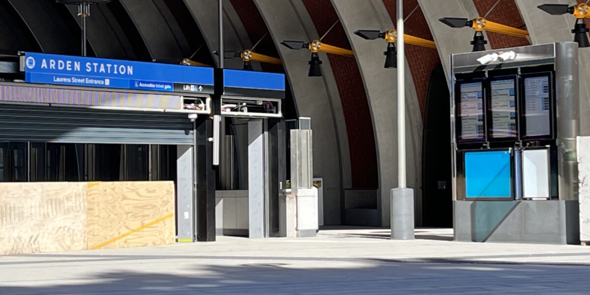
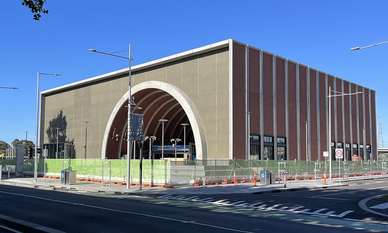
But at Arden in North Melbourne – where they did tours last year – the main entrance on Laurens Street is very visible.
They’ve installed bus stops. While there’s been no word yet of a connecting bus route serving Arden station, they’d need something in place for rail replacement buses.
There are several nearby bus routes. Diverting route 402 probably doesn’t make sense. Route 403 may end up being discontinued given it mostly duplicates the tunnel route. Extending or diverting 401 past Arden might make sense, adding a connection between North Melbourne and Arden stations, though making the trip to Parkville longer.
There’s signage visible from the street, above where people will enter. And apart that, there’s another interesting detail you can see.
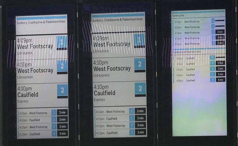
The screens at the entrance are switched on. With a zoom camera, we can make out what they’re showing.
What can we glean from the screens, with the obvious caveat that presumably it’s only for testing, and everything could change before the station opens?
The Sunbury line is going blue, joining the Cranbourne/Pakenham line. Not unexpected.
The lines together are listed by the somewhat unwieldly name of the Sunbury, Cranbourne & Pakenham lines. (I still think some kind of new line naming scheme might be good.)
Destination West Footscray? That’s quite possible, as that station was upgraded with an additional platform to allow trains to terminate there. But most trains will go to Watergardens and Sunbury.
Trains terminating at Caulfield is less likely during normal operations.
Trains to both of those destinations departing from both platforms 1 and 2? Unlikely. The usual platform numbering is 1 towards the City (and Caulfield in this case).
“West Footscray Ltd (Limited) Express”? Presumably this means not stopping at South Kensington, physically impossible given the track layout, but perhaps just copied from the current Sunbury line displays.
The current display of Sunbury line trains being listed as “Limited Express” is an issue – you can’t immediately tell if they’re just skipping South Kensington, or also running express Footscray to Sunshine, which some of them do in peak hour.
Another big problem here is listing “Caulfield” while not mentioning that those trains go through the City. This is something that’s already half-baked on the existing through-routed line from Frankston to Werribee/Williamstown.
They really need to properly fix this, and consistently display (Destination) via City or similar.
The times shown on the screens don’t seem to match reality. A train 1-2 minutes is unlikely, at least when the tunnel initially opens, though the in-cab signalling will allow high frequencies. It appears more likely we’ll initially see trains about every 5 minutes at most times. (Anything less frequent will jeopardise the tunnel’s success.)
Nitpicks aside, it’s really interesting to see them testing the screens, and I’m looking forward to the tunnel and the new stations opening in the next couple of years.


17 replies on “The next trains from Arden”
Let’s go with colours.
Blue line to Sunbury. Blue line to Westall. Blue line to Cranbourne. Etc. Matches the map. Easy :)
I’d do something with the 401 – it also pretty much duplicates the train and if it stays as a North Melbourne to Parkville shuttle it’s only needed for the Craigieburn and Upfield lines – there would be better ways of shuttling between those lines and Parkville maybe?
Interesting to see the screens on! I’ve always found this screen layout quite unhelpful though with the platform number being able to be confused with the waiting time, and the actual waiting time too small to read from a distance.
I think the 403 and 401 should both be discontinued and the resources diverted elsewhere in the bus network, as they’re both essentially duplicating the MM1 to service Parkville. Anyone travelling through Footscray can change there for a MM1 service to Parkville, while Cragieburn, Upfield line (and South Kensington Station!) passengers can change at Melbourne Central/State Library or Flinders Street/Town Hall to connect back the other way. While the Loop is in it’s current poor configuration (including midday reversal), this may perhaps be a very slight disadvantage to a some passengers – particularly those ending up at Flinders Street rather than Melbourne Central – but the benefits from shifting the resources elsewhere would surely outweigh the disbenefits.
Perhaps this could be an entirely new route connecting Arden Station with the local area, although such a route is not immediately obvious in an area that’s already well-serviced by train, tram and bus.
IIRC Blue has belonged to the “Caulfield loop” since it opened. I guess the average traveller doesn’t think of it that way but it would be a shame to break that history. What will we call that loop once Metro opens anyway?
Actually, Sunbury is going light blue (same as Cranbourne and Pakenham), as saying blue could imply Lilydale, Belgrave and Alamein lines as well, which are dark blue (Glen Waverley is proposed to be changed to brown once the tunnel opens).
Don’t read too much into the trains on the screens. This is a specific timetable set up purely for testing purposes. Hence only WeFo or Caulfield with non stops at insignificant stations. It bares no resemblance to the day one timetable or stopping conditions.
The platforms are mixed as both tracks are being tested. However when the tunnel opens, platform 1 will be for Sunbury and platform 2 for Cranbourne/Pakenham during normal operations.
Robert, the Caulfield Loop will still be the Caulfield Loop after the Metro Tunnel opens, even though it will just be Frankston trains running through the loop. But ther ecould be changes later on as the City Loop is reconfigured to allow Frankston and Craigieburn trains to run through without stopping at Flinders Street.
To Rick C, there is no connection with the Metro Tunnel to the Craigieburn and Upfield Lines, so I think 401 will still be needed to cater for those lines as they need to change at North Melbourne to get to Parkville. And 403 might be needed initially, but could be removed if V/Line passengers change to the Metro Tunnel in significant numbers.
But if I was to remove a route when the Metro Tunnel opens, it would probably by 403.
Is it just me – or do others get the two names confused? I always having to stop and calculate which is which: Cranbourne and Craigieburn? Is it a form of dyslexia perhaps. I have to think of the Cranbourne botanical gardens before I am satisfied that I haven’t swapped them in my head. Fortunately the Cranbourne line is not connected to the Craigieburn line – that would make my head spin.
Adding to the discussion on 401/403:
403 to Footscray only runs interpeak. It began in February 2016, a couple of years after RRL removed regional trains stopping at North Melbourne
ALP bus policy from the 2014 election (http://tinyurl.com/336c9ahb) suggests its only an interim fix until Parkville Station opens. So we can presume it’ll go.
Passengers on the inner half of the Upfield Line would mostly catch the 19 tram directly along Sydney Rd to Parkville and there’s also the option to transfer to the 58 tram at Royal Park, particularly for the hospitals.
Craigieburn Line passengers could be encouraged to use the 402 from Kensington with its 10 min all day frequency, although it can suffer from delays at the level crossings. 402 also connects at Macaulay for the outer half of the Upfield Line.
Possibly a modest increase in peak frequency to 402 would be enough to kill off 401 & reinvest the savings elsewhere.
However, there is another option that could have merit, incorporating Daniel’s suggestion to re-route 401 via Arden – 401 could be linked onto the 202 shuttle along Johnson St to form a east-west link from North Melbourne to Victoria Park (or even Kew)
202 currently terminates short of the hospital precinct & there’ll be future demand for a direct link to serve the Arden precinct from the inner north & connecting Doncaster buses etc
Savings from reducing 401’s current weekday frequency could be invested in a modest weekend service and/or midnight finishes for 402
two things:
– how long will it be for those screens to burn-in the current not-very-useful image
– how long will it take for Arden and other almost-complete-but-not-operating stations to appear in a movie or television drama of some kind (cf Canary Wharf)
@indigohex “there is no connection with the Metro Tunnel to the Craigieburn and Upfield Lines”.
Actually there’s two: you’ll be able to transfer underground from Melbourne Central Station to State Library, or from Flinders Street Station to Town Hall Station, and get the train to Parkville from there.
If you get a service that goes via the Loop (rather than Southern Cross), it’s then only one stop from State Library to Parkville. This would, I think, be better than transferring to a bus at North Melbourne Station, if only because the train-ride is a bit smoother than the bus,.
If you end up at Flinders Street Station, it’s a whole two stops from Town Hall, though that’s after a potential wait outside Flinders Street for a platform to clear before your train can pull in. This might be less preferable than the bus, but not drastically so, and mainly only where delays to the trains are concerned. Hopefully with the reduced congestion expected at Flinders Street Station, this won’t really be such a problem.
Passengers on Seymour VLine services would fare the worst, having to transfer twice: once at Southern Cross and again at Melbourne Central (or Flinders Street).
@Rick C, thank you for that. I forgot about the connections with the Metro Tunnel at Flinders Street (in the case of Town Hall) and Melbourne Central (in the case of State Library).
Check out the “2kmfromhome” map website (my favourite urban walking trails resource) – it clearly shows the underground alignment of the new cross city line, and also the SE arc of the SRL:
https://2kmfromhome.com/
@Matt – the data from that site comes from OpenStreetMap:
https://www.openstreetmap.org/#map=17/-37.80166/144.93755&layers=P
From an aesthetic perspective, I really like the design of Ardern Station and the Anzac tram interchange canopy. But I wonder if they are the latest examples of eye-catching design not being as practical as would be helpful in terms of shelter / protection from wet weather.
@Timbro The main issue is the high roof heights which adds grandiosity but at the cost of weather protection. I think the arched nature of Arden will allow it to fare a little better but I expect the roof at ANZAC to offer minimal protection. At least the platforms are underground so you dont have to wait under them…
The only line I feel that is left out and forgotten about is the Sandringham line