Since Sunday, the Frankston line has officially been connected to the Werribee/Williamstown line – the green line on the rail map.
So, let’s go catch a train.
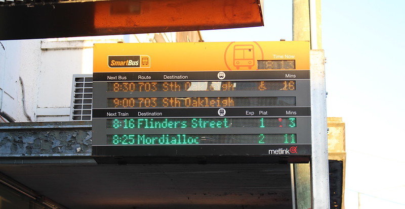
Outside some stations, the Smartbus signs can tell you the time and destination of the next trains in each direction. In this case, the next citybound train is the 8:16pm to Flinders Street.
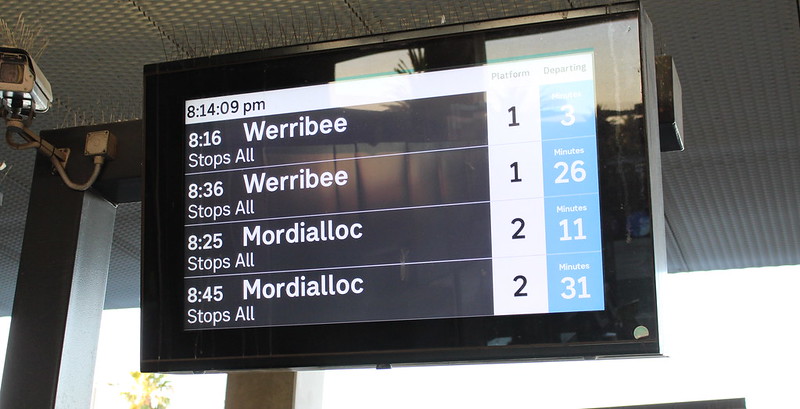
On the station concourse are these screens. They say the next train is the 8:16… to Werribee.
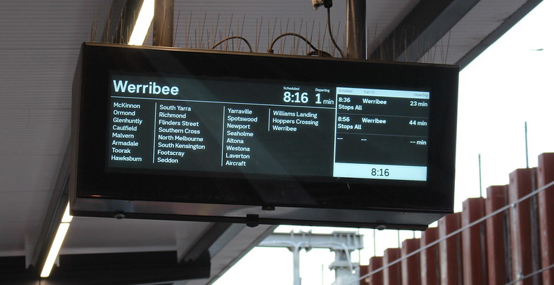
Down on the platform, yes, the 8:16 is going to Werribee. And somewhere in that long list of stations is Flinders Street in the City.
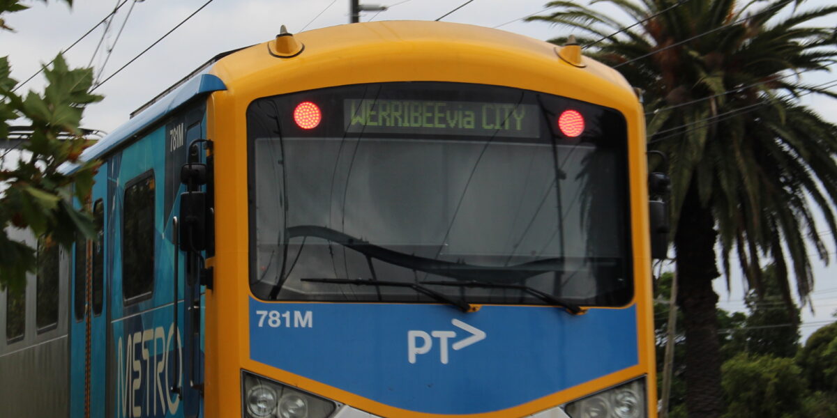
As the train arrives, the headboard finally spells it out: Werribee via City.
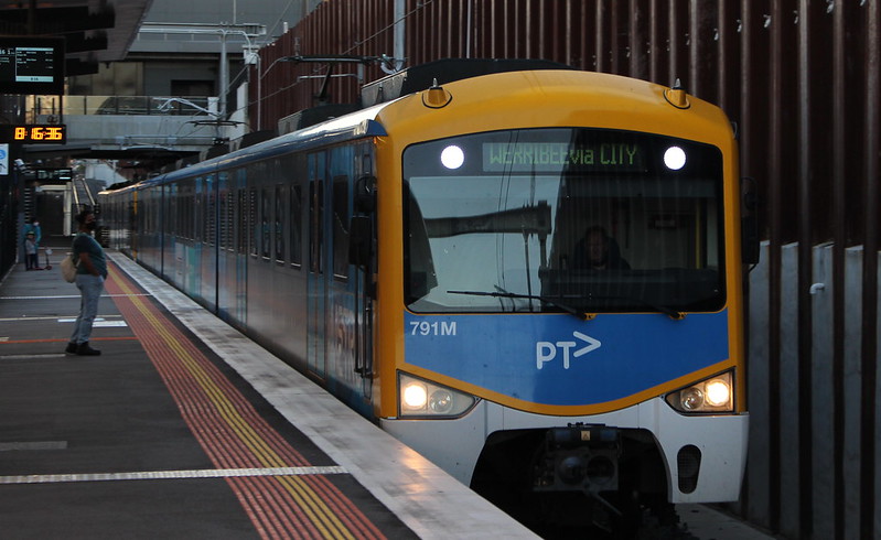
This is confirmed by the sign inside the train.

(This is on a Siemens train. It appears the X’Trapolis and Comeng trains are not able to show information X via Y destinations, at least not for cross-city journeys.)
There are two obvious problems here.
The first problem is consistency, so that passengers (especially new and occasional users) are not confused. As I understand it, there are technical limitations on the various devices and systems involved, meaning some can only show one destination. The Siemens trains are the exemplar here. Well, apart from the slightly squashed spacing on the headboard.
The second problem is emphasis. Displaying cross-city destinations is welcome, and helps people travelling from say Ormond to North Melbourne. But in most cases it has come at the expense of emphasising the main destination for most people: the City.
People on the other end of the Frankston to Werribee/Williamstown cross-city line are seeing the same thing: Frankston (etc) is more prominent as a destination than Flinders Street or the City.
Would someone in Frankston always know that a train to Laverton runs via the City? Does someone in Werribee always know that a train going to Carrum runs via the City?
Apart from mentioning the City, should they also distinguish between via the Loop and direct? I think there’s arguments both ways. Arguably it doesn’t matter at many suburban stations, as you should board the first citybound train regardless which CBD destination you want. And almost all stations now have detailed screens on the platforms which will still tell you precisely where the train stops.
For some stations (including on the Frankston and Werribee lines), whether the train is stopping all stations or express is the more important piece of information.
Even then, care is needed. Confusingly some inbound Frankston trains are shown as “Express” (see below) because after running through the City, part of their outbound run to Werribee skips some stations. This is part of a broader problem where any stations skipped means the train is an “express”.
The app is (was) worse
It could be worse. When looking at departures from a station on the Cross-city group, the PTV app splits citybound trains into multiple lines.
In the case of Frankston line stations, it lists them separately under “City”, “Werribee” and “Williamstown”.
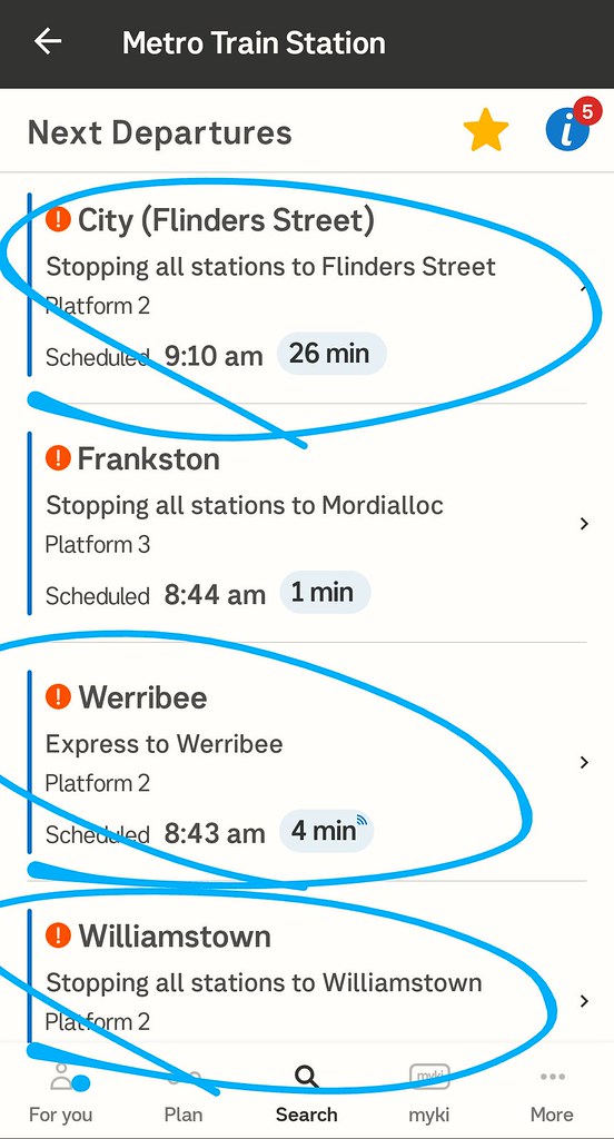
This meant if you just wanted to know the time of the next Citybound train, you had to look in three different places.
It’s similar on the other side of town: their citybound trains were displayed under “to City” and “Frankston line”.
And it appears that the app couldn’t show details of trains in the cross-city categories – this just produced an error.
The good news is that as of Wednesday they rectified this by switching the app back to just show trains going as far as the City. Which means the cross-city destinations aren’t immediately visible, but showing citybound trains in one spot is much more usable for most people.
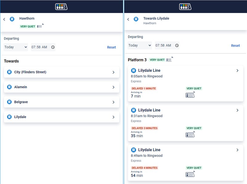
But it’s still a problem for lines with branches. For instance the Cranbourne/Pakenham line for outbound passengers is shown in as two separate lines in the app, and on the brand new (and very handy) Ridespace web site. Same issue on the Ringwood line. Travelling from Hawthorn to Camberwell? You’ll have to look in three places.
Transposals
Apart from the problems with passenger information, this week there are still issues with transposals – where you board a train going to A, and during the journey (typically at Flinders Street) it changes to go to B.
The promise was this would be stopped wherever possible. However it’s clearly still happening, including trains crossing between lines that are supposedly now running independently.
It’s only week one, so I’m hopeful this will be eliminated as time goes on.
These are not new problems
Transposals have been a problem for a long time, especially in the PM peak for Northern Loop passengers who board the train at Southern Cross, only to find its destination changed by the time it reaches Flinders Street.
Some of the app problems are years old, and have endured despite numerous updates.
While showing cross-city destinations prominently is new (perhaps not seen since the 1980s), trains running cross-city isn’t – many Frankston trains have run through to Werribee since at least 2010. And branches are definitely not new.
Okay, so the shiny new screens on stations are fed by older background systems, but you’d have hoped newer systems like the PTV app would be ready to show this information properly now that cross-city operation has been made fulltime.
This will be especially important once the Metro tunnel opens in 2025, providing a second cross-city group.
Meanwhile, paper and web timetables for Frankston confusingly still show Cranbourne/Pakenham train times, and vice versa, despite these now running independently, and being largely irrelevant to the other.
Likewise, Werribee and Williamstown timetables show Sunbury line times. But not, curiously, vice versa.
To their credit, PTV/DOT knows about all these issues, and they are trying to address them. In some cases fixing them may not be easy – some of them are embedded in various legacy systems that run the train network.
But hopefully in time they’ll be resolved.
- Which lines to display together and which to display apart isn’t always obvious. More reading: What if the train lines were given letters?
22 replies on “Catching the 8:16”
Rather than use the terminus as the naming convention, perhaps it’s time to consider line/group names, as some other systems use? So if it’s green on the map, this through-route would be Green line – eastbound, or Green line – City (but patrons would know it went on to Werribee), etc. You could name whatever, but it’d also ease the wholesale renaming of lines every time there’s a small extension, too.
Honestly don’t think it’s a massive deal whether they display via City or not (side note, there is no via loop needed, as all trains cross city trains now bypass the loop).
The map shows a clear green line from Frankston around the bay to Williamstown/Werribee. It’s not like there is a 2nd line that goes via Portsea and Geelong. As more and more lines become end to end, people will just have to get used to that. The only thing I would add is line colours to the displays to make it easier to spot on the maps.
A way to support this transition to a cross-city line is to have proper signage on the platforms that is appropriately colour coded to reflect the network map. London Underground does this very well, so you should be able to check that a train travelling in the eastbound direction will stop at your station even if it doesn’t travel all the way to the end of the line.
https://images.app.goo.gl/rB21hNw5HtbRVZMT7
As you noted, another way to build up confidence in the new system is to get rid of transposals wherever possible. A quick look at the app from yesterday I noted that there were inbound Dandenong services forming outbound Frankston and Craigieburn services. This will need to stop soon enough anyway when the HCMTs are rolled out, as not cleared to run on other lines.
From my journey yesterday, I also saw two inbound Dandenong trains within 10 minutes being altered to run direct to Flinders Street, meaning that this was effectively a cancelled service for anyone waiting for the corresponding outbound service at the remaining 4 city stations. This is something that was promised would reduce now that Dandenong has exclusive access to the loop. I can see why City Loop pax will prefer taking a Burnley loop train to Richmond and changing rather than going the long way around the loop just to find that the service that they thought they were on has already been transposed and left Flinders Street without them!
Almost every overseas railway system uses the terminus as the name of the line even when it’s some obscure village on the outskirts of the city. I don’t see an issue with using “Werribee” and “Frankston” as destinations. As a tourist the first thing you do is look at the network map and following a green line and seeing it passes through the city shouldn’t be that hard. This is consistent with other systems. As for locals the average person knows where both Frankston and Werribee are and can deduce that in the absence of a cross bay tunnel or bridge it’s going to go through the city.
The most important thing is consistency and suggesting keeping the legacy “city” naming around seems like a step backwards which will ultimately cause more confusion once new lines open up.
The challenge is that there are four basic bits of useful information: the line, how far the train is going on that line, which stations it stops at, and the route. Plus, you want to add a fifth: important stations along the route. That ain’t going to fit on any display, let alone the headboard.
My view is that the most important bit of information for most passengers is how far the train is going on that line – exactly what is being displayed on the headboard. The destination is particularly important on this corridor because many trains stop short and do not complete the run – mostly at Flinders St, but also at places like Cheltenham. If the concept of stopping short at Flinders St seems odd to you, this is probably because you are still thinking of this as two separate lines (Werribee and Frankston), not as one line.
Not all trains follow the same route on this line – some end up in Williamstown and some end up in Werribee. So this is yet another reason why the destination is important.
The line (e.g. Green line) is irrelevant to almost every passenger on almost all occasions. If I go to the local station I know that every train I catch is a Green line train. At interchanges the trains almost always use the same platforms – again if I go to the correct platform (which should be clearly labelled), there’s no need for the train to repeat the information. On the *rare* occasions when the platforms are stuffed up, the operator should go out of their way to communicate this.
An express/stopping indication is the next useful indication to most people – there’s no point in catching a train that runs through my destination without stopping. Since the are only a small number of unique stopping patterns that can be conveyed in a short sign, the number of stopping patterns should be limited. In particular, you must think of stopping patterns on the *whole* line from Frankston to Werribee. If the express/stopping pattern can vary on each side of Flinders St, that’s already four indications that you need to give. The consequence is that if a train is express on one side of Flinders St, it should be express on the other as well.
Fortunately, the route is now less relevant – all trains follow one route through the city. This should be conveyed by signage at the station, and, as in most transit systems, interchange signs in the carriages. In this context, loop versus direct is really a varient of fifth option: giving important stations.
Finally, flagging important stations. While useful, my view is that it’s the third level of importance – after the destination and stopping pattern. After all, destination and stopping pattern are something that most users will need every day, at least in one direction. Most passengers won’t need landmark stations. Landmark stations also depend on circumstances. During sports events, for example, it is likely to be more useful to highlight that trains go to at Richmond or Southern Cross rather than that they stop at Flinders Street.
Flagging important stations is most useful for passengers that rarely (or never) use the line or stations. For these people *signage on the station* is more important that signage on the train. One idea – common overseas – is to clearly label the city bound platform. This would be better than labelling trains as ‘Flinders Street’.
I noticed the same thing the other day at the station. A bit confusing at first, and for any other occasional travelers. Let’s hope PTV address this with your suggestion of adding ‘via City’ or ‘via Flinders St’ I notice that Phillip Mallis’ latest map of Metro train lines show the Frankston line route quite clearly. https://maps.philipmallis.com/australian-city-rail-maps/#melbourne
I agree with John S. – trains displaying ‘Werribee/Williamstown’ signage are clearly going via the city and are unlikely to cause confusion for passengers looking for a train to the city as the train will obviously travel through the City to get to their destination. Displaying ‘City’ instead takes away information that would be useful for passengers whose destination is beyond the city.
The app issue could be resolved by grouping all city bound destinations at a station (prior to the city) as they already do across multiple lines, but instead of labelling the train as “Stopping all stations to Flinders St/Southern Cross/Flagstaff/Parliament”, show the ultimate destination (ie. “Stopping all stations to Werribee).
This would allow the best of both worlds: showing all trains towards the city in one place, while showing the actual destination for those that need to know.
Interestingly, the app used to show trains on branch lines on the other branches option (such as “Stopping all stations to Clifton Hill” for a South Morang service when you were looking at trains to Hurstbridge), but no longer does this.
Some good comments!
I still don’t think someone on the west side of town will automatically know where Carrum is, and that a train to say Carrum is going via the City. This might be doubly-so when the SRL opens.
@andrew, while all Green line trains will run via Flinders St and Southern Cross, the route *can* vary – they can run to/from Werribee direct (weekdays until about 7pm) or via Altona (other times).
@Daniel
The weekday werribee direct trains still terminate at Flinders St platform 9
If you go to any frankston line station you will see that they alternate Williamstown/Laverton via flinders st platform 10 (and Frankston trains via platform 8)
@John, that might be the case during inter-peak periods, but can vary at other times of day. See the screendump from the app in the blog post, showing a “Werribee express” train from Bentleigh.
Like others, I see no problems with a train displaying the final destination. It’s been happening on the trams for years.
Quite an amusing article. I always wonder HOW these issues arise – it looks like no one who designs these systems actually uses public transport. Or perhaps the designers EXPECT the general public to assume a lot of knowledge before using PT.
@Daniel – Initially I was confused by your post as I thought you were catching the train FROM Werribee. You don’t actually state which station you are starting from. Unless I missed this!
The possibility of a transposal for any journey through Flinders St has been burnt into my memory over the years. Metro are kidding themselves if they think we’ll trust that they won’t happen just because they now say so, after years of telling passengers that they need to (re)check boards at Flinders St. I’ll continue to take loop services from Southern Cross to Richmond where practical rather than risk a transposal at Flinders St, even if it means an extra transfer rather than a one-seat journey.
@Daniel, Good point.
But that emphasises that you shouldn’t waste screen real estate on information that is true for all trains. You should highlight information that varies by train. This is particularly true for the destination boards.
I did a quick journey planner on the PTV app, Google Maps and Moovit this morning for a 9am trip from Moorabbin to Werribee. The PTV app told me to take the 9.02 train towards Flinders Street and to change at Newport (which of course is well past Flinders Street!), while both Google Maps and Moovit told me to change at Flinders Street. Going to the full pdf timetable on the PTV website, I could tell that the 9.02 was going to Williamstown – hence the change at Newport. And Google Maps and Moovit were also correct in getting me to change at Flinders Street for the following Werribee train. Not sure whether the no-change option of waiting for the next Werribee train at Moorabbin was given as a secondary suggestion. (This was an example I tried after reading the post this morning!)
One thing I did notice looking at the full timetable where it incorporates times on other lines – related to the commentary about multiple lines – for example the Werribee timetable will give me all train times for Footscray and Newport, and to the uninitiated might suggest that some trains on the line terminate at Footscray and Newport, rather than an indication that the train is continuing to other destinations.
And as noted in the comments above, cross-city trams have had their final destination shown for years, as have cross-city buses like the 216/219/220 (sadly not cross-city anymore!). Never any confusion there.
It also reminds me growing up in Bendigo that most city-bound buses showed their through-routed destination (which I think was also mentioned in the timetable too), even though that had a different route number. So inbound buses from Eaglehawk (on route 5) generally showed Kangaroo Flat 1 as the destination.
I think it’s just stupid, especially when in a few years time the Frankston trains will no longer be cross city. Go back to saying Flinders Street
It’s annoyed me for long time that the Frankston line and Pakenham/Cranbourne line have the same poster timetable and that the booklet timetable showed each other’s trains for their common stations.
Once most Pak/Cran trains started skipping the MATHs stations, it seemed to me that they should have separated the timetables, and simply showed the few Pak/Cran trains that did stop at MATHs in the Frankston timetable.
But now that no Pak/Cran trains stop at MATHs and no Frankston trains use the loop, it’s beyond ridiculous! The Pak/Cran lines now only share 5 stations with the Frankston line – but they share that many stations with the Northern and Clifton Hill lines, and they share 6 stations with the Ringwood lines! Perhaps there should be a single timetable for the whole network!?!
It makes the timetable twice as big as it needs to be with no real usefulness for anyone (except perhaps for people who use Caulfield Station, who have a train at least every 10 minutes at the worst of times, so are people who barely need a timetable at all…)
I support having the destination being shown on the destinations as is now happening. This is the ideal way of doing it.
Having said that, the destination MUST be consistent across the different displays. having one show Flinders Street, and the other saying Werribee, while most regular users would know the link between the two, anybody who is new to the system, are going to be as confused as all heck.
As for transposing, I dont mind so much, where the destination is changed before that destination has been set, but, once the destination has been set and advertised, there must not be any transposing after that point.
Given the Siemens trains are the only ones who can show ‘via’, could this mean, we see a lot more of the Siemens trains on the cross city line(s)?
Then again, Xtrapolis sets, do show ‘via city loop’, so, why cant they show ‘via city’.
As a Laverton line train leaves Flinders Street, I would value having them show ‘via Altona’
Today (9 Feb) Flinders St platforms 8/9, about 3.20 pm: train arrives platform 9, showing destination “Frankston”. No, it’s going back to Werribee. Hopefully everyone on board got the message. A couple of minutes later, train arrives at platform 8, showing destination “Flinders St” (with internal displays suggesting it’s been an “express”, presumably from Werribee. Turns out that this is going to be the Frankston line train. Eternal vigilance is still the order of the day at Flinders St, no matter what the stated destination might be.
It was remarked above that “As for locals the average person knows where both Frankston and Werribee are and can deduce that in the absence of a cross bay tunnel or bridge it’s going to go through the city.” Well, no. It’s important to have City marked and not good enough to leave it off.
I’m a very seasoned train user and live in the north east. I’ve never been down on the Frankston line; it’s the end of the earth to me up in Eltham. While I know where Frankston is I can’t tell you the name of any of the stations on that line. Therefore when I arrived at Footscray last week I wanted to check which of the six platforms would take me back to the city. I looked at all the displays in the overpass but was perplexed because none of them said City or Flinders Street and none of them said Frankston either. I was also unaware of the new arrangement of running the trains from the north to Frankston. I had to leave the station with the question unanswered. Upon my return I had to look at the phone app to find out that it was platform 5 – to Mordialloc, not Frankston, because the line was close beyond that station for track work. Other signage outside the station indicated platform 1 was for trains to the city, which only partially correct and in any case not the next train. I had no idea where Mordialloc was and at the time I thought it must have been further north.
If this confuses travellers who know the system fairly well where does this leave the casual train user let alone visitors?
[…] problems are creeping in elsewhere. I noticed yesterday that the Smartbus sign at Bentleigh station is only showing some train departures, but not […]