There are too many level crossing projects for me to track them all individually, but I am particularly interested in those at stations I’ve used regularly in the past.
Glenhuntly is one of them. Designs have just been released by the Level Crossing Removal Program.
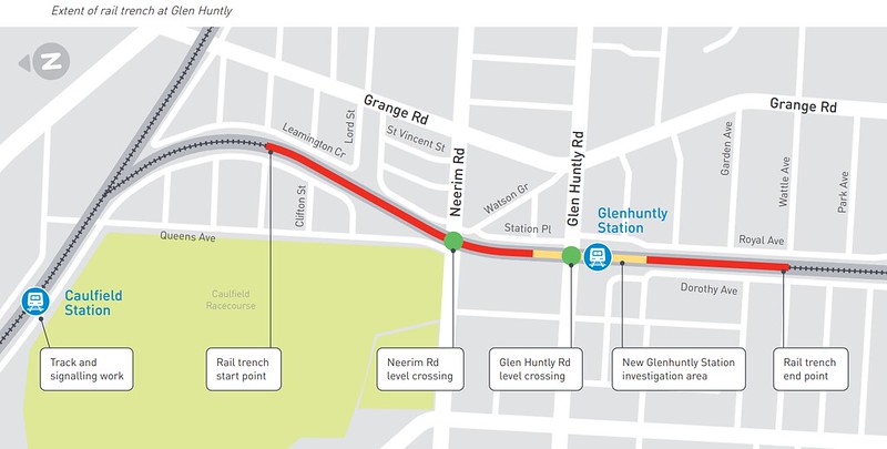
As had already been flagged, the rail line will be lowered underneath the road, with a trench about 1km long.
This project comes at a huge cost – a whopping $507 million to remove two crossings. These projects are important, but it’s getting a little embarrassing how expensive they have become. To put it in perspective, the government is spending $150 million to build eight primary schools.
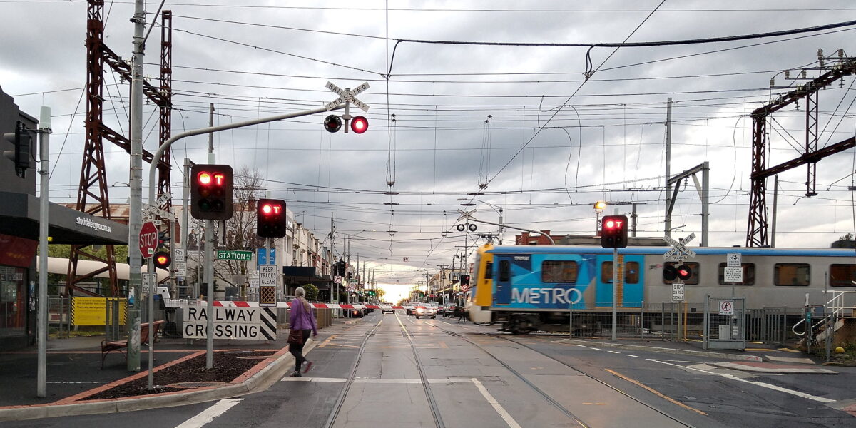
But of course, it’ll be great to have the crossing removed – the tram square (train/tram crossing) is one of only three left in Melbourne, and causes trains to slow to a crawl every time they cross, as well as delays to trams.
I’ll only show a couple of the newly released pictures here – go to the official web site to see the others.


Some thoughts on the design:
The station is remaining more-or-less in the current location, with the entrance still on the south side of the road.
However it appears passengers will enter the platforms near the middle rather than all at the northern end, which should help distribute people along the train, and reduce PM peak delays when train drivers sometimes have issues seeing if the doors at the rear of the train are clear to depart.
I like a grand entrance to a railway station – but the designers seem to be continuing the trend of providing a very high roof. It looks impressive, but experience from other stations shows is hopeless for shelter from the rain, which is rarely exactly vertical.
In which we are reminded that Melbourne rain isn’t vertical. Can someone tell the station designers? #Bentleigh ☔ pic.twitter.com/NDSZdMm52e
— Daniel Bowen (@danielbowen) April 9, 2017
I’m also not sure why they’ve positioned the station sign parallel with the street rather that making it visible along the street. Perhaps that’s just an issue with the render.
The new station will only have one entrance – which I think is a missed opportunity. The most obvious interchange – between trains and trams – will be fairly well served by tram platform stops and a pedestrian crossing immediately adjacent to the station (provided the traffic lights respond quickly to pedestrians).
But buses along Neerim Road (including services to Chadstone, the biggest shopping centre in Melbourne) will still be about 300 metres away, despite the northern end of the platforms being enticingly close.
The better integration with the shared path to Ormond is very welcome – though those campaigning for retention of some of the businesses between Royal Avenue and the station won’t be delighted that it appears they’re all disappearing.
And one more thing – perhaps the least important, but easiest to fix: the name. They’re not changing the spelling to be consistent with the suburb.
After I wrote about this issue in January, I raised it in the online consultation:
Obviously this is not the most critical of issues compared to some of the great questions being asked here, but rebuilding Glenhuntly station seems like a good opportunity to rename it to be consistent with the suburb it serves, Glen Huntly. Will it happen?
And the official reply:
We are following the existing naming convention, which is Glen Huntly for the road and the suburb, and Glenhuntly for the station.
Changing the current convention and ensuring consistency in the naming is not something that is within the scope of our project.
We recommend you speak with Glen Eira City Council in the first instance if this is an issue you would like to pursue.
I don’t think the council has any say in this whatsoever. But I’ve sent in a query to them about it anyway.
The reluctance to just fix the name is nonsensical. No wonder people get cynical about public transport planning in this state. If they can’t fix the easy stuff, what hope do they have on the difficult stuff?
The lost opportunities aside, the bottom line is that – finally – the crossing will be gone by 2024 – which is great news for the local community and for every passenger on the Frankston line.
Update 2/7/2021:
LXRP suggested I contact the council about changing the station name to match the suburb and the road.
— Daniel Bowen (@danielbowen) July 2, 2021
The council got back to me. As suspected: "Council does not play a role in the naming of train stations."
And: "However we agree with your position…" pic.twitter.com/hdsfUKaeqH
15 replies on “Glenhuntly station designs released”
The year at the end is meant to be 2023, not 2024 🙂
While removal of level crossings is a great thing, how on earth can removal of two crossings cost over half a billion dollars?
Daniel, I wonder if one of your PT construction friends could give their two bobs worth on this?
@Michael, the official timeline says the boom gates will be gone in 2023, but I’m not assuming this means the station will be operational at the same time, which is why I’ve used the project completed year of 2024.
@Roger, I get the sense that the cost has been creeping up in part because there are so many big construction projects at the moment. The hope was that economies of scale (lots of level crossing removals) would bring costs down, but it hasn’t turned out to be the case.
I suspect that the loss of the businesses between the station and Royal Avenue and the new entrance being to the south of Glen Huntly Rd are both about finding enough space for a concourse and platform access for all 3 platforms that connects to Glen Huntly Rd and its trams directly. A concourse further south would not connect to Glen Huntly Rd directly. A concourse to the north would struggle to have enough space to access platform 3, because of Station Place being much closer to the railway than Royal Avenue.
As the platform extends under Glenhuntly Rd then you would think access would also be from the northern side via stairs or lift.
The roof is too high and exposed, it needs to shelter people from the rain and wind. It doesn’t blend into the streetscape.
Thanks for this. What I couldn’t find was any sort of map or aerial view of the new layout. It doesn’t look (from the first picture) that there’s any provision for bikes on Glen Huntly Road. I also note that cars and trams have to share the same narrow bit of road outside the station. I admit to not using GH Rd so I’m unaware of the general situation – are cars permanently trapped behind trams or are there opportunities to pass?
That price tag almost makes all those multi-storey car parks seem cheap by comparison.
The LXRP video, at least, suggests the station will be open in 2023: https://youtu.be/_q7ta6nk3w4?t=48
I suspect the cost is mostly made up and the government just nods and signs the dotted line. That’s how all government infrastructure projects work.
Regarding the name Glen Huntly and the ‘Glenhuntly’ usage, there must have been a fashion for mashing names together like this a century or so ago, as there has been for undoing this in recent decades. Another is Western Port: when I was growing up in the 1970s it was always ‘Westernport’ or even ‘Westernport Bay’ as seen in the Melway until sometime in the 1980s, even though of course Western Port is the European traditional name. It went so far at one point that I’ve seen ‘Eastmalvern’ in some old railway timetables.
Place names were put under the jurisdiction of local councils in the 1990s (which saw the dramatic shrinking of less-fashionable suburbs like Burwood, Chadstone and Moorabbin) but I doubt this extends to the names of railway stations. I’d expect the buck should stop with DoT as the responsible authority here.
Too many artsy fartsy stations designs that aren’t practical. I’d like stations with full weather protection rather then these patch work roofs that look good for 10 seconds until the design is out of date and passengers are left with an inferior station.
Ugh, yet another Mitcham (but at least it has three tracks, unlike Mitcham which had its siding removed). Why can’t we build stations with actual cover anymore? The station shown in the artist’s impression couldn’t be further from the footpath and is surrounded by absolutely nothing, leaving everyone open to the weather which is either freezing and wet, or 40°C in full sun.
Tony: Mordialloc is also another obscure one when it comes to spelling. It is apparently an Aboriginal name similar to Woori Yallock (yallock basically meaning creek – guess what, there is conveniently a Mordialloc Creek nearby, much like the Woori Yallock Creek in the latter suburb, as well as a Wandin Yallock Creek not far from there either), but for some reason both suburbs/towns were given completely different spellings. Anyone for Mordi Yallock or Woorialloc?
Wow, over $500 million for 2 crossing removals. Victoria’s BIG BUILD comes with very high costs: all that construction, all that demand for resources is clearly increasing costs. Taxpayers are paying dearly for all this. Many crossing projects have had little impact thus far, see the damning 2017 report by the State’s Auditor-General. It’s a poorly programmed suite of projects. AND the contractors get the nod on another crossing removal when they start an earlier one. So they know they’re in the box seat and no need for them to ‘sharpen their pencils’. The whole thing is a huge scam. Just so Dan can tick another box.
[…] (The suburb is spelt as two words, the station as one. No, they’re not fixing the discrepancy, despite building an entirely new station. No, it doesn’t make sense.) […]
[…] when I enquired, the LXRP said they wouldn’t do it, and referred me to the local council… which has no power on this […]