You might have spotted this in The Age or on the government’s web site: the preferred route and station locations for Metro 2 through Fishermans Bend have been announced.
Rewind a moment: What is Metro 2? I’ve got an explainer I wrote a few years ago, but to summarise: just as Metro 1 is a NW to SE rail tunnel connecting the Sunbury and Dandenong lines, Metro 2 would be SW to NE rail tunnel, connecting the Werribee line via Fishermans Bend, the CBD, Parkville, Fitzroy and Clifton Hill to the Mernda line.
The concept could also include electrifying the Geelong line and running it into Metro 2, for a faster, more direct journey into central Melbourne.
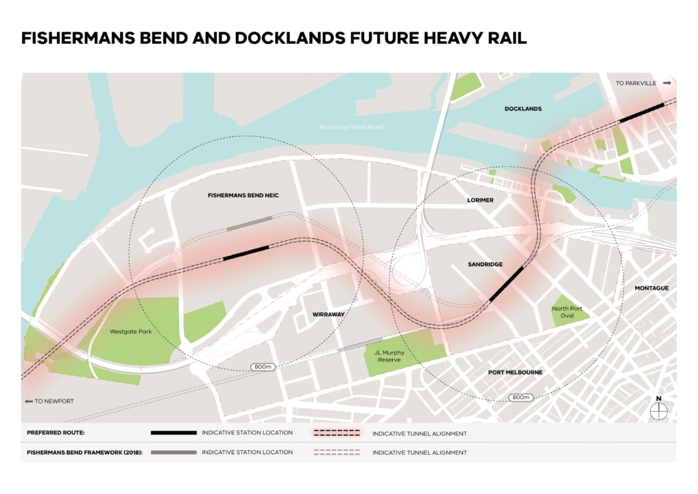
So, here’s the map they released:

Some observations on the preferred route just announced:
This is important, as Fishermans Bend is set to be a huge residential and jobs area in the decades ahead. Ensuring good quality public transport through the area is essential to making it work – otherwise it’ll be an inner-city precinct where most people drive, and get into traffic snarls.
So it’s good that the State Government is progressing their planning on this.
Two stations is good. Mass transit close to where people need to travel is what’s needed. This is a failing of parts of SRL, which for instance has no stops between Southland and Clayton, more than 7 km as the crow flies.
The local Fishermans Bend buses have improved over the years, but as I understand it they can still get overwhelmed at peak times, and full-scale development of the precinct hasn’t even really started yet.
It’s also very good that there’s a station planned on each side of the freeway, which is set to be a real problem as the area develops – a huge barrier splitting the precinct’s two halves.
A “freeway lid” might be possible – this is where they cover part of a freeway with a bridge used for green space or other (non-road) development. They’re popular in the USA for mitigating the effects of inner-urban freeways.
A mix of frequent surface modes, bus and tram, will also be important to complement the trains, particularly for local trips and journeys that are not along the rail corridor.
The map indicates the station would be under the street.
The station at Docklands under Bourke Street is interesting. That’s intended to be the interchange to Southern Cross. Previously it’s been assumed that this station would be closer to, or even underneath SC, but that might be prohibitively expensive.
The location adjacent to Marvel Stadium could work, but it’ll need to be very well designed, with a direct paid-area pedestrian route between the stations, preferably straight onto the suburban platforms at SC. (Time to resurrect the subway?)
It’ll also need to be easy for people going to/from the western end of the CBD.
Newport, Parkville, Flagstaff, Fitzroy?
On the left of the map an arrow points to Newport, reflecting the connection from the Werribee line. This will vastly improve public transport from the inner-west into Port Melbourne and Fishermans Bend. Currently passengers have to travel via Southern Cross – in contrast to the multitude of car lanes feeding directly into the area from the Westgate Bridge.
The arrow on the right of the map points to Parkville, which fits in with what we knew previously: the route plans an interchange there, and in fact Parkville station has been designed with provision for that.
What’s missing from the map is any mention of a station at Flagstaff. It’s not clear if this is still in the plan. This is important because if the City Loop reconfiguration project eventually goes ahead, the Frankston to Craigieburn line connection won’t provide any interchange elsewhere for passengers to Fishermans Bend.
Also not shown is the north-eastern side of the line, from Parkville east (and you’d hope they include station at Carlton and Fitzroy, as previously envisaged) connecting through to the Mernda line. Perhaps they’re still doing the planning work on that.
Metro 2 might be decades away of course, but it’s good that planning is progressing. The question is: will it get funded and built by the time Fishermans Bend needs it?


14 replies on “Metro 2 Fishbend preferred route”
Running the Geelong Line through MM2 is a good idea. It might need to be that Mernda trains run express to Geelong (maybe via GFR corridor?) and stopping-all trains continue to use Werribee or RRL tracks. Even so, it may create an unbalanced East/West load and whatever new underground Southern Cross station should include turnaround and terminus platforms. Ideally four or six – far more than current requirements. Imagine one day a high-speed Adelaide service departing from an underground Southern Cross terminus!
My understanding is that the greatest bottleneck currently to running more V/Line services in peak time is turnaround capacity at Southern Cross: not enough spare platforms for all the trains. Pulling out all of Geelong and shoving it all in the MM2 tunnel would free up a lot of SC capacity for improvement to other regional lines. This could be a very good way of selling the MM2 project as an uplift to every regional line (in the same way as MM1 was sold as an uplift to every metro line).
If the new underground Southern Cross station was a new terminus with many departing platforms, it probably should get its own distinct name. A name used by one future fantasy map was “Wurundjeri” and I really really like that as a new welcome portal to the city, directly underneath Wurundjeri Way.
@Jesse, I believe the thinking was to run the Geelong trains further north to a terminus somewhere around Thornbury, to avoid having to build lots of underground platforms at great expense.
@Daniel, that is very interesting about a terminus at Thornbury for Geelong trains. Sounds like (hopefully!) they might take the opportunity to remove or at least improve the sharp bend at Thomas Kidney/Rushall Reserves; the low bridge over Merri Parade; and the Charles St/Clarke St level crossing.
I think it could be argued that Metro 2 should be a higher priority than the Suburban Rail Loop, especially if there is demand by developers before they will commit. I’ve experienced crowded Port Melbourne buses. Crowded trains and trams are bad enough.
While I agree with @Andrew in principle, the one project we don’t need is the Northeast Link, which will result in more traffic and the need to build more motorways, and the circle continues (remember an episode of Utopia in which a road project was to be built and it was found it would cause more traffic within 2 years). And remember that Suburban Rail Loop will be built over 30 years and the Metro 2 will be six-seven years. So if we scrap the Northeast Link, then both Metro 2 and Suburban Rail Loop will be theoretically feasable. So it is theoretically possible to do both Metro 2 and Suburban Rail Loop but as a consequence scrap Northeast Link which is not needed.
I wish this project was prioritised before the SRL East. The benefits would just be a lot more far reaching than the SRL East.
This could also free up capacity in the loop for Electrification to Bacchus Marsh and Whyndam Vale.
Daniel, I get triggered whenever the Southern Cross subway is mentioned. It’s closure – especially the section which safely facilitated movement underneath Spencer Street – remains mind boggling. While the platform ramps are not DDA compliant, they would provide a further option for many passengers, reduce crowding on escalators and make moving east-west across Spencer St much safer.
Helpful observations. Good that some degree of planning is happening. Plans for the section between Parkville and Clifton Hill would be good to see. A major revamp of rail to and through Werribee, Williamstown, Altona, Wyndham Vale and Geelong is needed. MM2 could be a catalyst for that.
Anon, while MM2 would have a larger impact in the short term, SRL is a generational project which has the potential to start changing Melbourne’s transport culture. The integrated planning underway for SRL will fundamentally improve how we house and transport an increasing population.
A big frustration with SRL is the puzzling decision not to have any stations between Cheltenham and Clayton. In an ideal world the first stage would also have extended to Doncaster, introducing heavy rail to the City of Manningham for the first time.
Is there such capacity pressure on the Mernda/Hurstbridge line south of Clifton Hill that relief is essential, or could MM2 actually continue easterly and also become the long-anticipated Doncaster line?
@boris it’s better to go to Mernda given how busy that line is coming. This then frees the capacity at Clifton Hill to consider a Doncaster line. Which won’t be as busy as a Doncaster line.
@Boris, yes the most at-capacity section of line on the entire network is Clifton Hill inwards. So much so that it was a shortlisted location for CBTC trials for the Metro Tunnel, and would likely be the first place to get a future CBTC or ETCS rollout. It is a location where two duplicated tracks merge at one set of tracks, effectively halving the capacity of each feeder line. So far we make do in peak hour barely by running express services between stop-all. Removing one branch and putting it in MM2 would be by far the better solution – and if it were Mernda, there is also capacity to remove the Rushall Reserve bend. A simpler project would probably be to extend SRL East to Doncaster so that Doncaster can catch a quick service to box hill to take an express Burnley Group service.
@Jesse @Boris Giving the Mernda Line its own sector running through into Metro Tunnel 2 has another benefit on top of removing the curves north of Clifton Hill: you provide the Mernda Line enough capacity to build the proposed branch through Epping North to Wollert. In future you can also extend the Mernda Line back to Whittlesea. The Hurstbridge Line also has full use of a Loop track so you can then look at branching that to Doncaster.
Not sure if this is relevant to the post, but let’s go back to Metro Tunnel 1 here and another milestone has been reached with Grattan Street being reinstated effective 14 July 2024 (https://www.ptv.vic.gov.au/footer/about-ptv/improvements-and-projects/bus-and-coach/buses-return-to-grattan-street/). I think with the reinstating of Grattan Street will allow easier connections between buses on Grattan Street and Parkville Station when the Metro Tunnel opens in late 2024/early 2025. Parkville will serve as a good model when it comes to integrating other modes of transport into the Metro Tunnel 2 when it is constructed (note that the construction of Parkville has left room open for Metro 2 which will serve Parkville Station.
@Jessie, I would actually use Naram for the proposed station that you are thinking about rather than your suggestion of Wurundjeri, and that is because in Sydney with the new Metro line, they are using “Gadigal” for one of the new stations as part of the driverless Sydney Metro (Gadigal is the indigenous name for Sydney, while Naram is the indigenous name for Melbourne).