Here’s an update on the state of level crossing removals.
I’ve done these lists before: 2020, 2018, 2017, 2014.
They’re all based on the 2008 ALCAM list, which ranked Victoria’s level crossings by risk. It’s now pretty old, and rankings would have changed due to different road and train traffic growth, but it’s still the best document publicly available.
Again I’m listing the top 300 (which covers all crossings in metropolitan Melbourne, as well as some regional locations)… with three others also listed at the bottom because they’re now planned for removal.
Here’s the list. You can skip below to some observations.
| Rank | Type | Line | Road | Suburb | Status 11/2022 | Year completed | Design | 2022 pledges | |
|---|---|---|---|---|---|---|---|---|---|
| 1 | Metro | Ringwood | Springvale Rd | Nunawading | Completed | 2010 | Rail under | ||
| 2 | Metro | Dandenong | Springvale Rd | Springvale | Completed | 2014 | Rail under | ||
| 3 | Metro | Ringwood | Mitcham Rd | Mitcham | Completed | 2014 | Rail under | ||
| 4 | Metro | Sunbury | Main Rd | St Albans | Completed | 2016 | Rail under | ||
| 5 | Metro | Sunbury | Furlong Rd | St Albans | Completed | 2016 | Rail under | ||
| 6 | Metro | Upfield | Bell St | Coburg | Completed | 2020 | Rail over | ||
| 7 | Non-Metro | Werribee St | Werribee | Completed | 2022 | Rail over | |||
| 8 | Metro | Dandenong | Clayton Rd | Clayton | Completed | 2018 | Rail over | ||
| 9 | Metro | Craigieburn | Macaulay Rd | Kensington | |||||
| 10 | Metro | Mernda | Bell St | Preston | Underway | 2022 | Rail over | ||
| 11 | Metro | Craigieburn | Glenroy Rd | Glenroy | Underway | 2022 | Rail under | ||
| 12 | Metro | Dandenong | Grange Rd | Carnegie | Completed | 2018 | Rail over | ||
| 13 | Metro | Werribee | Cherry St | Werribee | Completed | 2022 | Road over | ||
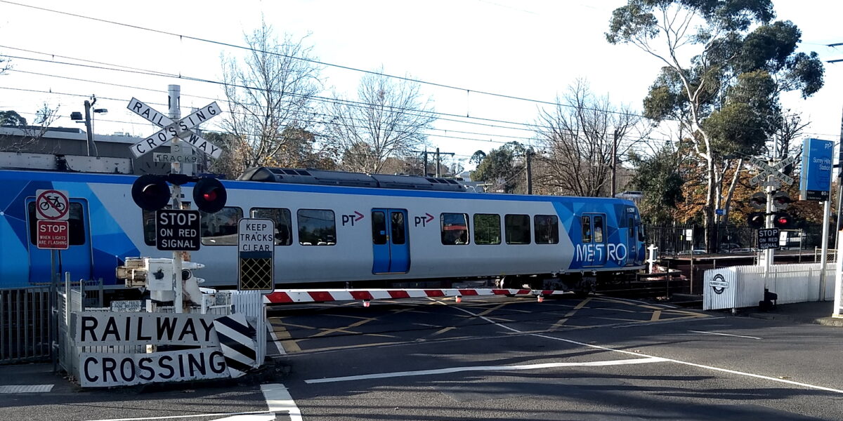
| 14 | Metro | Ringwood | Union Rd | Surrey Hills | Underway | 2023 | Rail under | ||
| 15 | Metro | Frankston | North Rd | Ormond | Completed | 2016 | Rail under | ||
| 16 | Metro | Werribee | Aviation Rd | Laverton | Completed | 2019 | Road over | ||
| 17 | Metro | Ringwood | Blackburn Rd | Blackburn | Completed | 2017 | Rail under | ||
| 18 | Metro | Craigieburn | Buckley St | Essendon | Completed | 2018 | Road under | ||
| 19 | Metro | Werribee | Old Geelong Rd | Hoppers Crossing | Completed | 2022 | Road over | ||
| 20 | Metro | Pakenham | Mc Gregor Rd | Pakenham | Underway | 2024 | Rail over | ||
| 21 | Metro | Alamein | Riversdale Rd | Camberwell | |||||
| 22 | Metro | Williamstown | Ferguson St | Williamstown | Completed | 2022 | Rail under | ||
| 23 | Metro | Hurstbridge | Lower Plenty Rd | Rosanna | Completed | 2018 | Rail over | ||
| 24 | Metro | Hurstbridge | Station St | Fairfield | |||||
| 25 | Metro | Mernda | Murray Rd | Preston | Underway | 2022 | Rail over | ||
| 26 | Metro | Frankston | Station St | Carrum | Completed | 2020 | Rail over | ||
| 27 | Metro | Dandenong | Centre Rd | Clayton | Completed | 2018 | Rail over | ||
| 28 | Metro | Frankston | Seaford Rd | Seaford | Completed | 2018 | Rail over | ||
| 29 | Metro | Upfield | Moreland Rd | Brunswick | Completed | 2020 | Rail over | ||
| 30 | Metro | Dandenong | Heatherton Rd | Noble Park | Completed | 2018 | Rail over | ||
| 31 | Metro | Frankston | Charman Rd | Cheltenham | Completed | 2020 | Rail under | ||
| 32 | Metro | Pakenham | Clyde Rd (Berwick – Cranbourne Rd) | Berwick | Completed | 2022 | Road under | ||
| 33 | Metro | Glen Waverley | Toorak Rd | Kooyong | Completed | 2020 | Rail over | ||
| 34 | Metro | Pakenham | Hallam Rd | Hallam | Completed | 2022 | Rail over | ||
| 35 | Metro | Frankston | Swanpool Av | Chelsea | Completed | 2022 | Closure | ||
| 36 | Metro | Pakenham | Racecourse Rd | Pakenham | Underway | 2024 | Rail over | ||
| 37 | Metro | Dandenong | Koornang Rd | Carnegie | Completed | 2018 | Rail over | ||
| 38 | Metro | Dandenong | Webster St | Dandenong | Planning | Road under | |||
| 39 | Metro | Glen Waverley | Tooronga Rd | Malvern | Coalition | ||||
| 40 | Metro | Dandenong | Chandler Rd | Noble Park | Completed | 2018 | Rail over | ||
| 41 | Metro | Frankston | Station St (Mascot Ave) | Bonbeach | Completed | 2020 | Closure | ||
| 42 | Metro | Frankston | Skye Rd (Overton Rd) | Frankston | Completed | 2018 | Rail over | ||
| 43 | Metro | Mernda | Keon Pde | Keon Park | Planning | 2025 | Rail over | ||
| 44 | Metro | Upfield | Gaffney St | Coburg North | |||||
| 45 | Metro | Pakenham | Sth Gippsland Hwy | Dandenong | Completed | 2022 | Road over | ||
| 46 | Metro | Werribee | Kororoit Creek Rd | Altona | Completed | 2010 | Road over | ||
| 47 | Metro | Werribee | Maidstone St | Altona | Planning | 2030 | Road over | ||
| 48 | Metro | Belgrave | Scoresby Rd | Bayswater | Completed | 2016 | Rail under | ||
| 49 | Non-Metro | Ballarat / Geelong | Anderson Rd | Sunshine | Completed | 2014 | Rail under | ||
| 50 | Metro | Pakenham | Webb St | Narre Warren | Planning | 2025 | Rail over | ||
| 51 | Metro | Sandringham | South Rd | Brighton | |||||
| 52 | Metro | Pakenham | Main St | Pakenham | Underway | 2024 | Rail over | ||
| 53 | Metro | Glen Waverley | High St | Glen Iris | Coalition | ||||
| 54 | Metro | Hurstbridge | Grange Rd | Alphington | Completed | 2018 | Rail under | ||
| 55 | Metro | Dandenong | Corrigan Rd | Noble Park | Completed | 2018 | Rail over | ||
| 56 | Metro | Lilydale | Maroondah Hwy | Lilydale | Completed | 2022 | Rail over | ||
| 57 | Non-Metro | Ballarat / Geelong | Fitzgerald Rd | Ardeer | Underway | 2022 | Road over | ||
| 58 | Metro | Craigieburn | Puckle St | Moonee Ponds | |||||
| 59 | Metro | Mernda | Cramer St | Preston | Underway | 2022 | Rail over | ||
| 60 | Metro | Frankston | Centre Rd | Bentleigh | Completed | 2016 | Rail under | ||
| 61 | Metro | Alamein | Prospect Hill Rd | Riversdale | |||||
| 62 | Metro | Mernda | Normanby Av | Thornbury | |||||
| 63 | Metro | Upfield | Box Forest Rd | Glenroy | |||||
| 64 | Metro | Sunbury | Anderson Rd | Sunshine | Completed | 2014 | Road under | ||
| 65 | Metro | Upfield | Brunswick Rd | Brunswick | Planning | 2027 | Rail over | ||
| 66 | Metro | Sandringham | Hampton St | Hampton | |||||
| 67 | Metro | Glen Waverley | Burke Rd | Glen Iris | Completed | 2016 | Rail under | ||
| 68 | Metro | Dandenong | Poath Rd | Hughesdale | Completed | 2018 | Rail over | ||
| 69 | Metro | Frankston | Lochiel Av | Edithvale | Completed | 2021 | Closure | ||
| 70 | Light Rail | 96 | Bridport St | South Melbourne | |||||
| 71 | Metro | Glen Waverley | Glenferrie Rd | Kooyong | Coalition | ||||
| 72 | Metro | Mernda | High St | Reservoir | Completed | 2019 | Rail over | ||
| 73 | Metro | Werribee | Hudsons Rd | Spotswood | Planning | 2030 | Rail over | ||
| 74 | Metro | Frankston | Edithvale Rd | Edithvale | Completed | 2021 | Rail under | ||
| 75 | Metro | Frankston | Glen Huntly Rd | Glenhuntly | Underway | 2023 | Rail under | ||
| 76 | Metro | Glen Waverley | Madden Gv | Burnley | |||||
| 77 | Metro | Upfield | Macaulay Rd (Upfield line) | North Melbourne | |||||
| 78 | Metro | Sandringham | Glen Eira Rd | Ripponlea | |||||
| 79 | Metro | Dandenong | Murrumbeena Rd | Murrumbeena | Completed | 2018 | Rail over | ||
| 80 | Metro | Upfield | Munro St | Coburg | Completed | 2020 | Rail over | ||
| 81 | Metro | Frankston | Warrigal Rd | Mentone | Planning | 2025 | Rail over | ||
| 82 | Light Rail | 109 | Railway Av (Swallow St) | Port Melbourne | |||||
| 83 | Metro | Frankston | Chelsea Rd | Chelsea | Completed | 2021 | Closure | ||
| 84 | Metro | Frankston | Mc Kinnon Rd | McKinnon | Completed | 2016 | Rail under | ||
| 85 | Metro | Frankston | Argyle Av | Chelsea | Completed | 2021 | Rail under | ||
| 86 | Metro | Frankston | Highett Rd | Highett | Planning | 2029 | Rail over | ||
| 87 | Metro | Belgrave | Mountain Hwy | Bayswater | Completed | 2017 | Rail under | ||
| 88 | Metro | Ringwood | Mont Albert Rd | Mont Albert | Underway | 2023 | Rail under | ||
| 89 | Metro | Craigieburn | Devon Rd | Pascoe Vale | |||||
| 90 | Metro | Frankston | Bondi Rd | Bonbeach | Completed | 2021 | Rail under | ||
| 91 | Metro | Frankston | Eel Race Rd | Carrum | Completed | 2020 | Closure | ||
| 92 | Metro | Hurstbridge | Westgarth St | Northcote | |||||
| 93 | Metro | Hurstbridge | Victoria Rd | Fairfield | |||||
| 94 | Metro | Sandringham | Bay St | North Brighton | |||||
| 95 | Metro | Frankston | Station St | Seaford | Planning | 2029 | Rail over | ||
| 96 | Metro | Hurstbridge | Marshall St | Ivanhoe | |||||
| 97 | Metro | Ringwood | Heatherdale Rd | Ringwood | Completed | 2017 | Rail under | ||
| 98 | Metro | Frankston | Bear St | Mordialloc | Planning | 2029 | Closure | ||
| 99 | Metro | Werribee | Champion Rd | Newport | Planning | 2030 | Closure | ||
| 100 | Metro | Frankston | Armstrongs Rd | Seaford | Planning | 2029 | Rail over | ||
| 101 | Non-Metro | Ballarat | Grant St (Parwan Rd) | Bacchus Marsh | |||||
| 102 | Metro | Upfield | Dawson St | Brunswick | Planning | 2027 | Rail over | ||
| 103 | Metro | Upfield | Park St | Parkville | Planning | 2027 | Rail over | ||
| 104 | Metro | Belgrave | Bedford Rd | Ringwood | Planning | 2025 | Rail under | ||
| 105 | Metro | Frankston | Lincoln Pde / Groves St | Aspendale | Planning | 2029 | Rail under | ||
| 106 | Metro | Werribee | Anderson St | Yarraville | Planning | 2030 | Closure | ||
| 107 | Metro | Craigieburn | Gaffney St | Pascoe Vale | |||||
| 108 | Metro | Upfield | O Hea St | Coburg | |||||
| 109 | Metro | Altona Loop | Maidstone St (Altona Loop) | Altona | |||||
| 110 | Metro | Pakenham | Station St | Beaconsfield | Planning | 2025 | Rail over | ||
| 111 | Metro | Frankston | Park Rd | Cheltenham | Completed | 2020 | Rail under | ||
| 112 | Metro | Upfield | Boundary Rd | Fawkner | |||||
| 113 | Metro | Upfield | Albion St | Brunswick | Planning | 2027 | Rail over | ||
| 114 | Metro | Frankston | Balcombe Rd | Mentone | Completed | 2020 | Rail under | ||
| 115 | Non-Metro | Ballarat / Geelong | Station Rd (Mt Derrimut Rd) | Deer Park | Underway | 2025 | Rail over | ||
| 116 | Non-Metro | Bendigo | Oak St | Bendigo | |||||
| 117 | Metro | Mernda | Paschke Cr | Epping | |||||
| 118 | Metro | Mernda | Arthurton Rd | Northcote | |||||
| 119 | Metro | Mernda | Oakover Rd | Preston | Underway | 2022 | Rail over | ||
| 120 | Non-Metro | Ballarat | Humffray St | Ballarat | |||||
| 121 | Metro | Upfield | Arden St | North Melbourne | |||||
| 122 | Metro | Mernda | Regent St | Preston | |||||
| 123 | Metro | Lilydale | Dublin Rd | Ringwood East | Planning | 2025 | Rail under | ||
| 124 | Metro | Ringwood | Rooks Rd | Nunawading | Completed | 2014 | Rail under | ||
| 125 | Non-Metro | Stony Point | Moorooduc Hwy (Mc Mahons Rd) | Frankston | Coalition | ||||
| 126 | Non-Metro | Geelong | North Shore Rd (Station St) | Corio | |||||
| 127 | Metro | Sandringham | Greville St | Prahran | |||||
| 128 | Metro | Frankston | Parkers Rd | Parkdale | Planning | 2025 | Rail over | ||
| 129 | Light Rail | 109 | Beach St | Port Melbourne | |||||
| 130 | Metro | Werribee | Maddox Rd | Newport | Planning | 2030 | Rail over | ||
| 131 | Metro | Pakenham | Brunt Rd | Officer | Planning | 2025 | Road over | ||
| 132 | Metro | Hurstbridge | Ruthven St | Macleod | Planning | 2027 | Rail over | ||
| 133 | Metro | Pakenham | Progress St | Dandenong South | Planning | 2025 | Closure | ||
| 134 | Metro | Craigieburn | Park St | Moonee Ponds | |||||
| 135 | Metro | Mernda | Heyington Av | Thomastown | |||||
| 136 | Metro | Upfield | Reynard St | Coburg | Completed | 2020 | Rail over | ||
| 137 | Metro | Sunbury | Melton Hwy | Sydenham | Completed | 2018 | Road over | ||
| 138 | Metro | Frankston | Station St | Aspendale | Planning | 2029 | Rail over | ||
| 139 | Metro | Pakenham | Station St | Officer | Planning | 2025 | Closure | ||
| 140 | Metro | Sandringham | Church St | Brighton | |||||
| 141 | Metro | Frankston | Mc Donald St | Mordialloc | Planning | 2029 | Rail over | ||
| 142 | Metro | Lilydale | Manchester Rd | Mooroolbark | Completed | 2022 | Rail over | ||
| 143 | Metro | Upfield | Victoria St | Brunswick | Planning | 2027 | Rail over | ||
| 144 | Metro | Cranbourne | Abbotts Rd | Dandenong South | Completed | 2018 | Rail over | ||
| 145 | Metro | Sunbury | Taylors Rd | Keilor Downs | Completed | 2007 | Road under | ||
| 146 | Metro | Sandringham | Abbott St | Sandringham | |||||
| 147 | Metro | Mernda / Hurstbridge | Ramsden St | Clifton Hill | |||||
| 148 | Metro | Mernda | Settlement Rd | Thomastown | |||||
| 149 | Metro | Cranbourne | Thompsons Rd | Cranbourne North | Completed | 2018 | Road over | ||
| 150 | Metro | Frankston | Wickham Rd | Highett | Planning | 2029 | Rail over | ||
| 151 | Metro | Altona Loop | Kororoit Creek Rd | Altona | Completed | 2018 | Rail over | ||
| 152 | Metro | Frankston | Neerim Rd | Caulfield | Underway | 2023 | Rail under | ||
| 153 | Non-Metro | Freight / Overland | Separation St | North Geelong | |||||
| 154 | Non-Metro | Geelong | Lara Lakes Rd (McClelland St) | Lara | |||||
| 155 | Metro | Upfield | Barry Rd | Upfield | |||||
| 156 | Non-Metro | Ballarat / Geelong | Robinsons Rd | Deer Park | Underway | 2022 | Road under | ||
| 157 | Metro | Upfield | Union St | Brunswick | Planning | 2027 | Rail over | ||
| 158 | Metro | Sunbury | Calder Park Dr | Calder Park | Planning | 2025 | Road over | ||
| 159 | Metro | Mernda | Childs Rd | Epping | |||||
| 160 | Non-Metro | Geelong | School Rd | Corio | |||||
| 161 | Metro | Upfield | Camp Rd | Broadmeadows | Completed | 2018 | Rail under | ||
| 162 | Non-Metro | Ballarat | Hopkins Rd | Truganina | Planning | 2028 | Road over | ||
| 163 | Metro | Cranbourne | Greens Rd | Dandenong South | Completed | 2022 | Rail over | ||
| 164 | Non-Metro | Albury | Sisely Av | Wangaratta | |||||
| 165 | Non-Metro | Geelong | Yarra St | South Geelong | |||||
| 166 | Non-Metro | Albury | Arundel St | Benalla | |||||
| 167 | Metro | Mernda | Hutton St | Thornbury | |||||
| 168 | Metro | Upfield | Hope St | Brunswick | Planning | 2027 | Rail over | ||
| 169 | Non-Metro | Geelong | Windermere Rd (McIntyre Rd) | Lara | |||||
| 170 | Metro | Hurstbridge | Yarralea St | Alphington | |||||
| 171 | Metro | Hurstbridge | Main Hurstbridge Rd | Diamond Creek | Coalition | ||||
| 172 | Non-Metro | Freight / Overland | Thompson Rd | North Geelong | |||||
| 173 | Metro | Mernda | Woolton Av | Thornbury | |||||
| 174 | Non-Metro | Gippsland | Lloyd St (Waterloo Rd Cros) | Moe | |||||
| 175 | Metro | Upfield | Cemetery Ent | Hadfield | |||||
| 176 | Metro | Belgrave | Hilltop Rd (Railway Ave) | Upper Ferntree Gully | |||||
| 177 | Metro | Upfield | Bakers Rd | Coburg | |||||
| 178 | Non-Metro | Albury | Nunn St (Midland Hwy) | Benalla | |||||
| 179 | Non-Metro | St Georges Rd | Corio | ||||||
| 180 | Non-Metro | Mc Killop St | Geelong | ||||||
| 181 | Non-Metro | Gippsland | Ashby St | Trafalgar | |||||
| 182 | Metro | Mernda | Beavers Rd | Northcote | |||||
| 183 | Non-Metro | Ballarat | Station Rd / Exford Rd | Melton South | Planning | 2028 | Rail under | ||
| 184 | Non-Metro | Gippsland | Coleman St | Warragul | |||||
| 185 | Non-Metro | Albury | Faithful St | Benalla | |||||
| 186 | Metro | Sunbury | Gap Rd (Station St) | Sunbury | Underway | 2022 | Road under | ||
| 187 | Metro | Frankston | Latrobe St | Mentone | Planning | 2029 | Closure | ||
| 188 | Light Rail | Tram 109 | Inglis St | Port Melbourne | |||||
| 189 | Metro | Upfield | Poplar Rd | Royal Park | |||||
| 190 | Non-Metro | Gippsland | Tramway Rd | Morwell | |||||
| 191 | Non-Metro | Gippsland | Nar Nar Goon – Longwarry Rd | Nar Nar Goon | |||||
| 192 | Metro | Lilydale | Coolstore Rd | Croydon | Planning | 2025 | Rail over | ||
| 193 | Metro | Pakenham | Cardinia Rd | Pakenham | Underway | 2021 | Road over | ||
| 194 | Non-Metro | Geelong | Edgars Rd | Little River | |||||
| 195 | Non-Metro | Ballarat | Coburns Rd / Rees Rd | Melton South | Planning | 2028 | Rail under | ||
| 196 | Metro | Williamstown | Giffard St | Williamstown | |||||
| 197 | Metro | Belgrave | Alpine St | Ferntree Gully | |||||
| 198 | Non-Metro | Station Rd | Gisborne | ||||||
| 199 | Metro | Altona Loop | Millers Rd | Altona | |||||
| 200 | Non-Metro | Wood St (Fyans St/Carr St) | South Geelong | Planning | 2024 | Rail over | |||
| 201 | Metro | Mernda | Manns Crossing | Thomastown | |||||
| 202 | Non-Metro | Hamilton Hwy | Cressy | ||||||
| 203 | Light Rail | Tram 109 | Bridge St | Port Melbourne | |||||
| 204 | Non-Metro | Swanston St | South Geelong | ||||||
| 205 | Metro | Sunbury | Calder Hwy | Diggers Rest | Planning | 2026 | Road over | ||
| 206 | Non-Metro | Hope St (Bunyip – Modella Rd) | Bunyip | ||||||
| 207 | Non-Metro | Stony Point | Baxter – Tooradin Rd | Baxter | |||||
| 208 | Metro | Sandringham | Union St | Windsor | |||||
| 209 | Non-Metro | Parker St | Castlemaine | ||||||
| 210 | Metro | Sandringham | Linacre Rd | Hampton | |||||
| 211 | Non-Metro | Stony Point | Stony Point Rd | Bittern | |||||
| 212 | Metro | Mernda | Charles St | Northcote | |||||
| 213 | Non-Metro | Station Av | Heathcote Junction | ||||||
| 214 | Metro | Sandringham | Dendy St (New St) | Brighton | |||||
| 215 | Metro | Upfield | Albert St | Brunswick | Planning | 2027 | Rail over | ||
| 216 | Metro | Altona Loop | Pier St | Altona | |||||
| 217 | Non-Metro | Barwon Heads Rd | Marshall | Planning | 2024 | Road over | |||
| 218 | Metro | Hurstbridge | Wattletree Rd | Eltham | |||||
| 219 | Non-Metro | Wests Rd | Manor | ||||||
| 220 | Non-Metro | Birkett St | Euroa | ||||||
| 221 | Non-Metro | Eramosa Rd West | Somerville | ||||||
| 222 | Non-Metro | Freight | Kernot St | Spotswood | |||||
| 223 | Metro | Sandringham | New St | Hampton | |||||
| 224 | Non-Metro | Bank St | Avenel | ||||||
| 225 | Non-Metro | Kilgour St | Geelong | ||||||
| 226 | Non-Metro | Broadford – Epping Rd | Wallan | ||||||
| 227 | Non-Metro | Leakes Rd | Rockbank | ||||||
| 228 | Non-Metro | Knight St (Andrew Fairley Av) | Shepparton | ||||||
| 229 | Non-Metro | Freight | Francis St | Yarraville | |||||
| 230 | Non-Metro | Wahgunyah – Wangaratta Rd (Three Chain Rd) | Bowser | ||||||
| 231 | Non-Metro | Stony Point | Robinsons Rd | Frankston South | Coalition | ||||
| 232 | Non-Metro | High St (Hume Hwy) | Wodonga | Completed | Closure | ||||
| 233 | Non-Metro | Cowslip St | Violet Town | ||||||
| 234 | Non-Metro | Troups Rd Nth | Rockbank | ||||||
| 235 | Metro | Altona Loop | Grieve Pde | Altona | |||||
| 236 | Non-Metro | Marshalltown Rd | Marshall | ||||||
| 237 | Non-Metro | Mollison St (Kyneton-Trentham Rd) | Kyneton | ||||||
| 238 | Metro | Altona Loop | Civic Pde | Altona | |||||
| 239 | Non-Metro | Witt St | Benalla | ||||||
| 240 | Non-Metro | Bank St | Traralgon | ||||||
| 241 | Non-Metro | Creswick Rd (Midland Hwy) | Ballarat | ||||||
| 242 | Non-Metro | Barwon Tce | South Geelong | ||||||
| 243 | Non-Metro | Hayes St | Shepparton | ||||||
| 244 | Metro | Cranbourne | Camms Rd | Cranbourne | Planning | 2025 | Road over | ||
| 245 | Non-Metro | Lochs Creek Rd | Trafalgar | ||||||
| 246 | Non-Metro | Shady Creek Rd | Yarragon | ||||||
| 247 | Metro | Hurstbridge | Diamond St | Eltham | |||||
| 248 | Non-Metro | Frankston – Flinders Rd (Graydens Rd) | Hastings | ||||||
| 249 | Non-Metro | Sandford Rd | Wangaratta | ||||||
| 250 | Non-Metro | Canterbury Rd | Lara | ||||||
| 251 | Non-Metro | Benalla – Yarrawonga Rd | Benalla | ||||||
| 252 | Non-Metro | Kelly St | Wodonga | Completed | Closure | ||||
| 253 | Non-Metro | Lardners Track | Warragul | ||||||
| 254 | Non-Metro | Stony Point | Golf Links Rd | Baxter | |||||
| 255 | Metro | Lilydale | Cave Hill Rd | Lilydale | Planning | 2025 | Closure | ||
| 256 | Non-Metro | Station Ent | Seymour | Completed | Closure | ||||
| 257 | Non-Metro | Mc Diarmids Rd | Violet Town | ||||||
| 258 | Non-Metro | Reserve Rd | Grovedale | ||||||
| 259 | Non-Metro | Goulburn Valley Hwy | Murchison East | ||||||
| 260 | Metro | Hurstbridge | Wilson Rd | Wattle Glen | |||||
| 261 | Non-Metro | Western Hwy (Barkly St) | Ararat | ||||||
| 262 | Non-Metro | Telephone Rd | Trafalgar | ||||||
| 263 | Non-Metro | High St | Dimboola | ||||||
| 264 | Non-Metro | Donnybrook Rd | Donnybrook | ||||||
| 265 | Non-Metro | Osburn St | Wodonga | Completed | Closure | ||||
| 266 | Non-Metro | High St | Seymour | ||||||
| 267 | Non-Metro | Cochranes Rd | Wodonga | ||||||
| 268 | Non-Metro | Stony Point | Mornington – Tyabb Rd | Tyabb | |||||
| 269 | Non-Metro | Melrose Dr | Wodonga | Completed | Closure | ||||
| 270 | Non-Metro | Freight | Footscray Rd | Melbourne | Completed | 2009 | Road over | ||
| 271 | Non-Metro | Gardner and Holman Rd | Drouin | ||||||
| 272 | Non-Metro | Glenelg Hwy | Westmere | ||||||
| 273 | Non-Metro | Lake Rd | Stawell | ||||||
| 274 | Non-Metro | Freight | Somerville Rd | Brooklyn | |||||
| 275 | Non-Metro | Stony Point | Frankston – Flinders Rd (Hastings Rd) | Somerville | |||||
| 276 | Non-Metro | Queen St | Colac | ||||||
| 277 | Non-Metro | Fryers St | Shepparton | ||||||
| 278 | Metro | Craigieburn | Ascot Vale Rd | Newmarket | |||||
| 279 | Non-Metro | Stawell – Warracknabeal Rd | Glenorchy | ||||||
| 280 | Non-Metro | Nolan St | Bendigo | ||||||
| 281 | Non-Metro | Nagambie – Locksley Rd | Locksley | ||||||
| 282 | Non-Metro | Shanley St | Wangaratta | ||||||
| 283 | Non-Metro | Kennedy St (Koo Wee Rup – Longwarry Rd) | Longwarry | ||||||
| 284 | Non-Metro | Northern Hwy (Mary St) | Rochester | ||||||
| 285 | Non-Metro | Forest St | Wendouree | ||||||
| 286 | Metro | Hurstbridge | Railway Rd | Eltham | |||||
| 287 | Metro | Cranbourne | Evans Rd | Lyndhurst | Completed | 2020 | Road over | ||
| 288 | Non-Metro | Anakie Rd | Bell Park | ||||||
| 289 | Non-Metro | Stony Point | Hillcrest Rd | Frankston | Coalition | ||||
| 290 | Non-Metro | Stony Point | High St | Hastings | |||||
| 291 | Non-Metro | Bungaree – Wallace Rd | Wallace | Completed | 2020 | Closure | |||
| 292 | Non-Metro | Rutherglen – Springhurst Rd (Cannings Crossing) | Springhurst | ||||||
| 293 | Non-Metro | Surf Coast Hwy (Torquay Rd) | Grovedale | Underway | 2024 | Rail over | |||
| 294 | Non-Metro | Down St | Longwood | ||||||
| 295 | Non-Metro | Tylden – Woodend Rd | Woodend | ||||||
| 296 | Non-Metro | Nelson St | Bendigo | ||||||
| 297 | Non-Metro | Tynong Rd | Tynong | ||||||
| 298 | Non-Metro | Wimmera Hwy | Murtoa | ||||||
| 299 | Metro | Hurstbridge | Allendale Rd | Diamond Creek | |||||
| 300 | Non-Metro | Madden St North | Kaniva | ||||||
| … | |||||||||
| 302 | Non-Metro | Ballarat | Ferris Road | Melton | Planning | 2028 | Road over | ||
| 333 | Metro | Sunbury | Holden Road | Calder Park | Planning | 2025 | Closure | ||
| 473 | Metro | Sunbury | Watsons Road | Diggers Rest | Planning | 2026 | Road over |
Have I missed anything, or made any errors? Please leave a comment or shoot me a message!

Some observations
From the top 50 in 2008, there are now just 6 not currently removed or planned for removal.
If we look at the top 100, then 24 are not currently removed or planned.
Recent government announcements have focused on specific lines, so by 2030, several lines will be completely free of level crossings:
- Cranbourne/Pakenham 2025
- Lilydale 2025
- Sunbury 2026 – including removal of two semi-rural crossings outside the top 300
- Frankston 2029
- Werribee (excluding Altona Loop) 2030
Remembering the benefits crossing removals bring, this was unimaginable just a few years ago, and just goes to show what can be achieved with political will… and a lot of money.
While these lines will be free or road level crossings, they will still have some pedestrian crossings.
For the election on 26th November, the Coalition has pledged a few crossing removals on the Glen Waverley line, one on the Hurstbridge line, and by implication, several between Frankston and Baxter on the Stony Point line, as their pledge to extend metro trains also flagged crossing removals.
In contrast, Labor made a number of government announcements before the caretaker period started on Cup Day, so the assumption is that those will go ahead regardless of who wins the election. (This included two crossings in Highett that had been earlier pledged by the Coalition.)
So far Labor have not made any election promises of more crossing removals, preferring to trade off their record of 110 done by 2030.
Some projects on the list above do not seem to be counted in the 110. This includes regional crossings, as well as those completed before 2016, eg not initiated under the Andrews government.
Still notable is that not a single crossing on the Sandringham line has been planned or pledged. Alamein too, though this is shorter has far fewer crossings and fewer trains.
I’m on the Frankston line – so my line and several others will be crossing-free by 2030! It’ll be interesting to see the benefits of improved reliability – not just reduced risks of crossing incidents, but also via the renewal of a lot of rail infrastructure.
If there are more pledges in the lead up to the election, I’ll add them in the list above.
I’m also planning a follow-up blog looking at some of the patterns emerging with the program.
- PTUA’s State election scorecard
- 18/11/2022: Updated to correct the Kororoit Creek Road crossings – I had the lines muddled. (Thanks Mark)
18 replies on “Level crossings – November 2022 update”
The number of crossings in Melbourne removed or bring removed is up to 112 as of today. They are saying 110 but they are not including Anderson Street and Champion Road on the Werribee line, as they don’t want to draw attention to road closures, even though many have already been counted in the list until now. Being election season, closures are suddenly sensitive.
You missed Maidstone street on the Werribee (main) line.
Quite a few of the level crossings on your list shown as Underway are already gone, e.g. Bell St, Cramer St, Oakover Rd and Murray Rd in Preston, Cherry St Werribee, Glenroy Rd Glenroy, Gap Rd Sunbury, Fitzgerald Rd Ardeer, etc. Landscaping etc. for the projects may not be complete (although I thought Cherry St was well and truly done and dusted) but the crossings are gone and the lines are running as normal.
(Robinsons Road Deer Park also gone.)
“.. not a single crossing on the Sandringham line has been planned or pledged.”
Grrrr. Guess which line I live on! OK, there is nothing like self interest to get people fired up.
Also Cardinia Rd Pakenham is Completed, not Underway.
The benefits of removal aren’t so clear cut in all areas. Ours in Williamstown North – we measured in 2017 prior to the boom gates being removed, and again just recently. In 2017 the down time – boom gates and pedestrian crossing lights – was 38 minutes in the 2 -hour morning peak, measured on a Wednesday. The recent survey showed that stoppage time had INCREASED to 44 minutes in the 2 hour morning period, a 21% increase in delays. This is due to pedestrians having access to a second pedestrian-activated crossing. Whenever you go near the station precinct now you can be sure you will be facing a red light. The community argued strongly that pedestrians were the main source of delays prior to boom gate removal, and we sought a pedestrian link from the other side of the road to the underground platforms. This was refused on the grounds that it ‘couldn’t be done due to DDA compliance’. We argued that DDA access was available at the station entrance and that surely not EVERY entry point needed to be DDA-compliant? We were fobbed off by the ‘experts’ and no one in Govt responds to emails….
AS for URBAN DESIGN aspects, I suspect that many of these crossing removals have caused new problems for communities, not to mention the horrible bulk and appearance of some of them. In my view, they have been done in haste, and with little regard to all aspects, not simply the engineering aspects. I feel very sorry for communities such as around Buckley St Essendon, where the road trench has cut the area in half and isolated the local shopping strip. Also for the communities of Mont Albert and Surrey Hills who have lost their stations in favour of a new station which has worse access. There truly needs to be a wide-ranging evaluation of the Level Crossing Removals Program that assesses a range of parameters.
@James, thanks – have put in details for Maidstone St (Werribee main line)
@Ross, yes – I’ve used the LXRP status – which in some cases shows the crossing removed but the project is still continuing. In those cases I’ve marked them as Underway.
@Anna, great points you make there. I haven’t seen the Nth Williamstown site since it was done, but it did seem like an odd one to prioritise given the low number of trains using the line.
With regard to the total delay time per 2 hour peak, is there data on the length of each delay? At many sites, the length of each individual delay is much lower and is more predictable – you don’t get long waits for multiple trains anymore. And traffic light red time can also be overridden (ignored) by emergency vehicles.
Essendon has been a mess. Poor result for pedestrians and cyclists, and the station itself wasn’t touched, and still has accessibility problems.
Some other abolished level crossing on the 2008 ACLAM list between 300 and 473:
303. Anglesea Rd, Mount Dundeed.
357. Princes Highway, Warncoort.
389. Hovell St, Wodonga.
431. McCarten St (Roughead St), Leongatha.
463. Murray Valley Hwy(Thomas Mitchell Drive), Wodonga.
The Glenferrie Rd crossing’s delay has always vexed and bewildered me. Was it always about the LAB govt punishing the LIBs? Or was it too hard? Not doing it at the same time as Toorak Rd seemed like a waste of effort to me.
Is the spreadsheet/table available somewhere where one can sort it? (Like a lot of the tables in Wikipedia are.) It would be good to examine the data sorted by line or date.
@Anna
“This is due to pedestrians having access to a second pedestrian-activated crossing.”
That second crossing is synchronised to the first crossing though – i.e. they both go red and green at the same time, so I’m not sure that the increase in delays is due to that reason.
With their increasing boldness announcing entire lines free of LX and including street closures, I can imagine they could announce a LX-free Sandringham Line with perhaps 4 or 5 LXR but that would require several closures.
One to watch in Geelong, Reserve Rd, Grovedale could be a closure when Stage 1 of the Geelong Ring Road, Bellarine Extension is built. It’s not clear if they will leave it operating for the few houses between the crossing and where reserve rd will be cut off and replaced with the Ring Road.
https://bigbuild.vic.gov.au/projects/mrpv/geelong-ring-road-extension-bellarine-link
I worked briefly on ALCAM in 2009 and I can’t remember how the model allocates values, but I am curious as to how it managed to give Maroondah Hwy in Lilydale a higher risk rating than Dublin Rd and especially Bedford Rd, in Ringwood East. Both of these would probably carry less road traffic than Lilydale, but they carry more train traffic and the trains are always going faster (i.e. they can’t stop if the driver sees someone on the tracks). At Lilydale, all trains were either leaving the station so the driver had the option to simply not drive if someone moved onto the tracks, or approaching the station and already at a speed low enough to give a very good chance of stopping in an emergency. Congestion was also not an issue at Lilydale because the congestion was caused by the road traffic squeezing through the town, and the series of traffic signals it encountered. The crossing was activated relatively rarely because there are so few trains, in comparison with properly served stations closer to the city on the same line.
I’m glad they did do the LIlydale work and they have produced a reasonably good result overall, but I really question whether it had to be done before Dublin Rd and Bedford Rd. Both of those will have had fatalities and Bedford is on an angle and right next to a school and a complex set of road intersections.
[…] is trading off its record since 2014, with 67 level crossings removed, and projects currently funded and underway to get that number to […]
Of the crossings that are currently in the planning or proposed/future stages, should the Liberals get in, would those ones be aborted? or is it too late to stop them now?
[…] updating the level crossing removal list last month, I was interested to see how many of each type of removal had been […]
[…] in recent decades than what we’ve seen since 2014 when he became Premier. Dozens of level crossing removals (and rail lines and stations rebuilt) and the Metro tunnel nearing […]