A few people have asked me about this in the past few months — what if Bentleigh had got “skyrail”?
It’s interesting to consider, though it was never going to happen.
Firstly, the timing was wrong. The Coalition had fully funded the Ormond level crossing for removal in May 2014, with designs already having determined that it would be rail under road. In late-2014 the incoming Labor government spotted an opportunity to piggyback the Mckinnon and Bentleigh crossings onto it, which made logistical sense as well as political sense — Bentleigh being a marginal electorate, they knew to have the multiple crossings removed before the 2018 election would be a plus.
It was only after the Level Crossing Removal Authority came into being that alternative strategies such as elevated rail have been considered.
Secondly, having rail over road may have caused complications at the southern end, where the rail line goes under Brewer Road, necessitating rebuilding of the road overpass.
There are pros and cons with every design. By missing skyrail, we missed out on some good outcomes.
No doubt some locals are relieved rail is going into a trench. But rather than elevated rail and a park outside their back fence, they get an impassable cutting. The jury’s still out on whether noise is worse at ground level from skyrail or trench rail.
Better outcomes from skyrail?
Murray Road pedestrian/cyclist crossing — local campaigners are continuing to fight for this, but the presence of a storm water pipe means the project team says the only viable solution is an at-grade crossing. Will it happen? Only if the safety audit comes up green and the minister can stomach approving an additional (non-car) level crossing as part of a level crossing removal project. With skyrail it would have been easy.
More pedestrian access — apart from Murray Road, there could have been additional pedestrian/cyclist (and possibly even motorist) crossing points anywhere and everywhere. The most obvious locations are midway along Glen Orme Avenue (Ormond, where the tennis courts access is provided), connecting Foch Street and Leila Road (Ormond), Blair Street and Ward Street (Bentleigh), and connecting the car parks just south of Centre Road. Mind you there aren’t unlimited opportunities, as for most of the length of the rail line in this section, there are houses on at least one side.
More efficient train operation. Apparently it can be a difference of up to 6% of energy consumption, as stations underneath ground level require extra braking and extra power to depart and accelerate out. This will be particularly apparent with the design as planned, where the line will come back up to surface level between stations.
Better stations. With a high proportion of costs of trenched rail going into moving underground services, and bus replacements, if these can be avoided then more can be spent on the stations and other outcomes — this seems to be what’s proposed on the Dandenong line. It’s not really working out cheaper overall, but stations are getting fully-enclosed weather cover, and (at least some; it’s not finalised) escalators — none of the Ormond-Mckinnon-Bentleigh stations will have escalators, although parts of the platforms will be underneath the roads, partly enclosing them from the weather.
Future 4th track without disruption. Supposedly if skyrail goes ahead on the Dandenong line, the 3rd and 4th tracks will be able to be built largely without disrupting the initial two tracks. It’s unclear what will happen if the 4th track ever goes in on the Frankston line. It might require partial closure again to widen the cuttings.
Pictured: Nicholson Street: October 2015 vs December 2015 after tree clearing
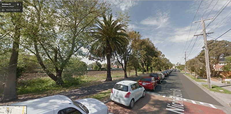
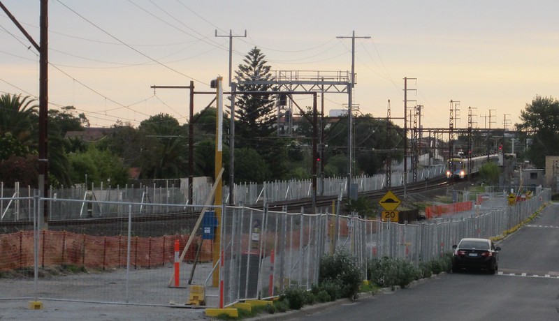
Saving more trees. While a special effort has been made to remove and store the palm trees for re-planting later, almost every other bit of flora in the corridor has been cleared away. From some angles it resembles a moonscape.
As this Dandenong line FAQ notes: One of the benefits of the elevated rail design is the ability to retain trees and vegetation close to the rail corridor. By elevating the rail line, we minimise our impact to the root systems of trees, and are able to retain a significant amount of trees within the rail corridor.
Parkland underneath. Glen Eira council is forever reminding us that they have less green space than anywhere else in the state. Some of what little green space there is in Bentleigh will be taken by car parking, to make up for a small loss of spaces at Ormond. Skyrail could have enabled more green space right along the line.
Continuous bike/shared user path. The current project will restore the bike path from Bentleigh to Mckinnon, but there still won’t be a connection from Mckinnon to Ormond — cyclists and walkers have to divert via local streets, because the rail corridor is too narrow. If it were skyrail, a shared user path could easily fit underneath.
A more prominent train system. Some might not consider this important. But out-of-sight, out-of-mind is a concern. At ground level or elevated, the trains are prominent. Hide them away and they are less obvious to people. Does that influence how people think about their transport choices? I don’t know.
Trains will still be visible in their trench of course, if you’re a pedestrian walking by, but less so if driving past. Hopefully good prominent signage and stations will make up for that. (I’d like to see signage include a countdown timer to the next trains, more prominent than the one we once had.)
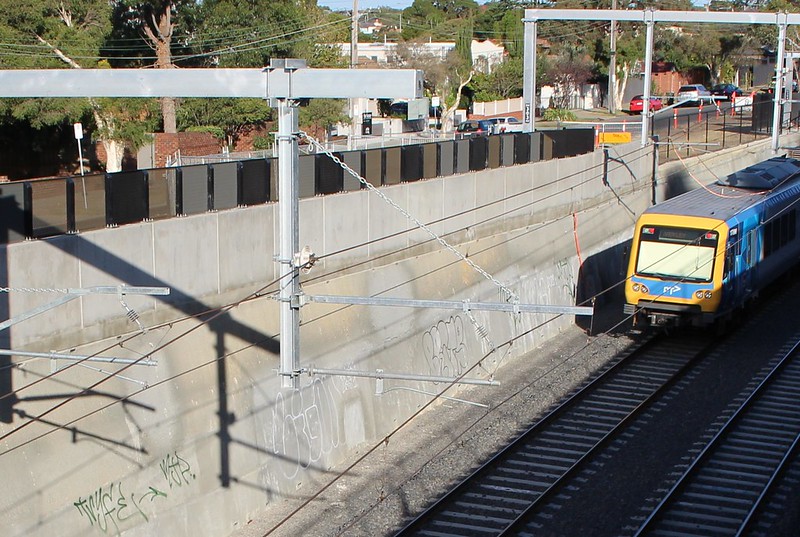
Better views from the train. OK, no biggie, but it’s more pleasant looking out over your suburb than staring at a plain (or graffiti-covered) wall. It’s also easier to navigate if you can see where you are.
That said, the current plan is for trains to return just about to street level between stations. Roller coaster!
Train trench, Gardiner. Opened in January. Already tagged.
And then of course there’s the disruptions
Road and rail shutdowns. The LXRA claims Dandenong skyrail will involve about 15-20 weekend shutdowns, and two longer shutdowns of 9 and 16 days. Yesterday the government claimed that if it was done as trenches, the Dandenong line would require shutdowns “for 230 days during construction” and that “these closures would be between 30 hours and eight weeks long”.
For the Bentleigh project, it’s shaping up as numerous weekend shutdowns, plus 9 days (January 2016), 10 days (Easter 2016) and the big one: about 35 days (TBC; June-August). That’s a total of about 70-80 days in all, though in some cases (such over the past weekend) they closed the line for the weekend as early as 7pm on Friday.
The list of line closures so far is:
- Third track closed (thus reducing capacity, and resulting in several cancellations daily) Mon 16/11/2015 until the project is finished in July 2016
- Last two trains after midnight, Fri 13/11/2015
- 1am Sat 21/11/2015 to last service Sun 22/11/2015
- 1am Sat 28/11/2015 to last service Sun 29/11/2015
- 1am Sat 12/12/2015 to last service Sun 13/12/2015
- First service Sat 23/1/2016 to last service Sun 31/1/2016
- 8:45pm Fri 12/2/2016 to last service Sun 14/2/2016
- 7pm Fri 4/3/2016 to last service Sun 6/3/2016
And expected as the project progresses:
- 9pm Fri 19/3/2016 to last service Sun 21/3/2016
- Closure of Ormond and Mckinnon stations 25th March to late July 2016
- First service Fri 25/3/2016 to last service Sun 3/4/2016
- Closure of Bentleigh station from 4th June to late
JulyAugust 2016 - Expected line closure from 25th June 2016 for about 5 weeks
Each time, they warn of travel time increases by up to 45 minutes. During the January shutdown, lot of people gave up and drove, switched to other train lines (causing crowding elsewhere), or made other arrangements.
Closures don’t just affect train passengers — many involve closing roads, which affects local businesses. There were claims of huge loss of earnings at Burke Road, Gardiner (though it was never the busiest of shopping centres). To counter the problem, the government has organised (no doubt at considerable expense) full colour brochures promoting local shops, sent to every resident in the area, and an accompanying web site. (I notice that the site lists Milsims Games, which moved out of Bentleigh some years ago.)
Would there be fewer shutdowns with skyrail? Parts of the alignment are very tight — perhaps tighter than the section through Carnegie. The north side of Mckinnon station looks like it’s a similar width to the narrowest section between Carnegie and Murrumbeena, but it’s got three tracks in it, not two. And what you don’t want to be doing is acquiring properties if it can be helped. (For the current design it was avoided.)
Hopefully it would have been possible to stagger the construction, building elevated new rail lines above the older ground level lines while they continued to operate.
The key is minimising weekday shutdowns, especially outside school and university holidays. Weekday shutdowns require 100+ buses in operation, as well as numerous support staff — two at every station replacement bus stop, plus many more at the interchanges from first to last service. There are often temporary road markings or modifications, signage, traffic light modifications and traffic monitoring. It’s a very, very expensive undertaking. (We don’t know quite how expensive, but by comparison, recent V/Line bus replacements have cost up to $300,000 per day.)
And…Frankston line suspended. One of the perils of putting rail under. #MetroTrains https://t.co/cbVaGgj1hd
— Daniel Bowen (@danielbowen) February 12, 2016
Risk of unplanned disruptions. So far I’m aware of only one incident: on February 12th, excavation at Bentleigh for the crossing hit a gas pipe, causing a leak, with a sudden road and rail line closure for some hours. As passengers who have been caught up in one know, any unplanned rail closures are messy. Buses often can’t be got to the scene quickly, and are rarely sufficient, especially if the closure extends into peak hours.
Truck movements. Apparently 280,000 cubic metres of earth are to be dug up and moved out. Expect to see thousands of truck movements in the area, particularly during the main shutdown in June/July/August.
E.E.Gunn Reserve partly closed. Parts of this park will be closed for months to temporarily store the earth. One of the benefits of skyrail is that components can be built off-site and shipped in and assembled, like some kind of massive Ikea flatpack — and of course there’s little or no earth to dig out and take away.
Stations shut. As noted above, Mckinnon and Ormond stations are shortly to close for about four five months. Bentleigh will close for a shorter period of about two three months. (Some of this overlaps with the entire line closing for about 5 weeks.)
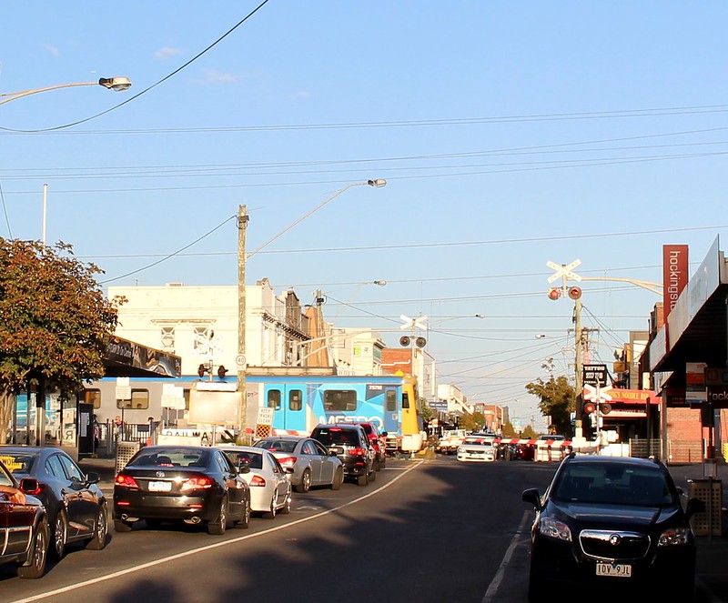
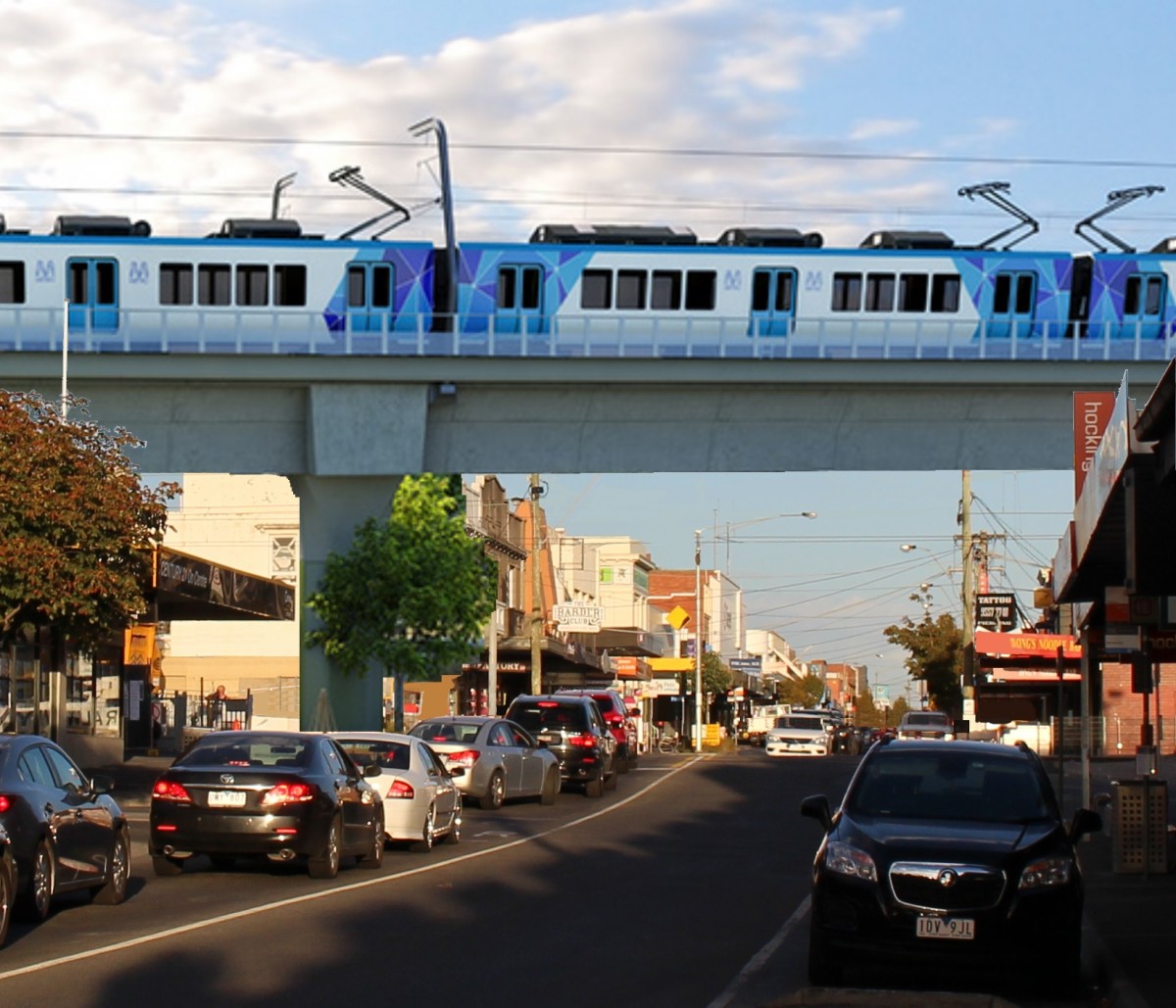
Bentleigh now vs what if Bentleigh had skyrail? Yeah, my Photoshop skills aren’t up to much.
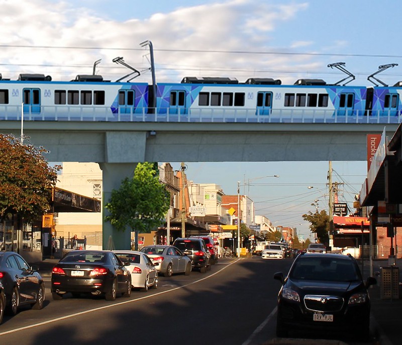
Would it have been possible?
A Vicroads contact suggested skyrail might not work over North Road, because of space issues, but a slight re-alignment might have solved that. Certainly the road overpass in Brewer Road in Bentleigh may have caused problems.
Would it have been politically feasible? I wonder if the government could have stomached the risk in the very marginal seat of Bentleigh? They may yet face a similar conundrum further south on the Frankston line.
We might never really know, but had the concept of elevated rail been considered earlier for the Bentleigh area, the potential was there for a project with far fewer disruptions, and some markedly better outcomes for locals.
19 replies on “What if Bentleigh had got Skyrail?”
We need to be careful about assertions of “park land” around sky rail. Obviously, grass and vegetation cannot grow beneath an overpass as light levels are very low and there’s no water at all. What tends to happen is that the space below the overpass becomes a barren dust bowl. This barely constitutes “open space” that has any real value to anyone. The overpass will also overshadow the land corridor on the southern side which will also impact on the sort of plants and grass that can be grown there.
There is no sustainable way to grow grass and vegetation under the sky rail, so it has to be used for something else. Bitumen? Paving? Car park? Even clever and thoughtful vegetation plantings around the skyrail will not compensate for this.
I am not anti skyrail per se, but the horticulture needs to be seriously considered if this is to be used as a selling point.
@Adam – it’s simply not true to say that vegetation can’t grow under elevated rail. There are plenty of examples to demonstrate this. For example, explore the BART line through Berkeley California using Google Streetview. It has an elevated line with parks and bike/walking trails underneath, and low density standalone houses all along the corridor.
https://goo.gl/maps/6zHeNfXgDcT2
Just to add: the light and rainwater issue is precisely why the Dandenong skyrail is designed to have separate narrow structures for each track, rather than one big one. One large structure would certainly lead to problems as Adam says – similar to these road overpass pictures.
I’ll have to take travel sickness medication every morning to ride the roller coaster! I can’t comprehend how there would be enough distance to come back to almost street level begore needing to descend again to the next station. I wonder what the rationale is for doing that?
On the topic of the “opportunity to piggyback” projects together, it’s a shame they did not fix up the Kooyong station crossing, the Toorak Road crossing, Tooroonga Road crossing and the High St, Glen Iris crossing together with the Burke St grade separation. Though I can imagine it will be utter chaos on the roads.
>The jury’s still out on whether noise is worse at ground level from skyrail or trench rail.
Also I’m wondering if there are train fans around the world who has done this comparison. It wouldn’t be too hard to do one here in Melbourne as we already have a mix of both.
@Arfman – the noise debate is a bit misleading.
Passenger rail built in Victoria after 2013 must comply with the Noise Policy, no matter whether at-grade, elevated or lowered. It’s almost a certainty that current rail does not meet this requirements of this policy, as there was no policy prior to 2013, and many corridors have been in place for 100+ years.
No point trying to find noise examples using any pre-2013 elevated rail structures in Victoria, as they are not representative of what is now required to be built.
http://economicdevelopment.vic.gov.au/transport/about-transport/passenger-rail-infrastructure-noise-policy
(You’ll notice the Liberal MP skyrail agitators have stopped calling it “noisy skyrail” because it can’t be noisy, based on the policy introduced during their last term of government.)
Hey Belinda,
I don think it will actually be that bad. Between Bentleigh and McKinnon currently there is a big dip, you dont notice it on the rain but stand at either end now with all the tree gone you can see it.
By the time they put the underpasses in the line will nearly be flat through this section.
I don’t have time right now to do a proper analysis, so just a few quick thoughts-
1. The obvious problem is that rail-over was not taken seriously by the coalition in 2014. Apparently is was suggested by the engineers, but never got anywhere because the people in charge were afraid of the political fallout.
2. Rail-over could easily have returned to ground level before the Brewer Rd bridge, though obviously it would have been preferable to demolish and flatten Brewer Rd and link the elevated line to Patterson, already elevated.
3. The cutting currently under construction apparently has “passive provision” for a fourth line, which is supposed to mean no new infrastructure (i.e. retaining walls) is built to forbid it. But I can’t see how that would work – adding a fourth track on the alignment of the current Platforms 3 would not work because parts of the cutting could be 80cm too thin; and it would be preferably to place the fourth track on the west side anyway, to avoid conflicts at say Moorabbin between inbound express and outbound stopping. I’ve seen diagrams of McKinnon and Bentleigh (but not Ormond), indicating that the carparks soon to be built on the west side will need to be demolished, dug up and replaced with a wider cutting, which will probably involve temporary closure of No.1 track (citybound). Other parts of the alignment will need to be slewed; it’ll be almost the same scale of work as what’s currently happening.
Part of the problem is that while PTV has said in the past that the alignment is supposed to have provision for a fourth track, I haven’t been able to get a clear answer on whose job it was to make sure that it was included in the plans – things like cutting width etc. Someone signed off on the plans, and that person should have at least had access to an alternate (not for construction) plan showing the fourth track alignment.
I went through Gardiner about 7:15pm last night; it’s been retagged. Your photo is dated 3rd March, so sometime in the intervening five days and nights.
The railway between Carnegie and Murrumbeena is 20.1168m wide (1 chain), probably through historic accident since that section of line was added after the Richmond-Brighton and Bunyip-Oakleigh bits. A solid deck with room for four tracks, no curves and no platforms, requires about 21m to 22m width depending on design. You’d want a lot more than that to allow for parkland underneath, but then it’s a question of priorities.
The thinnest part between Glenhuntly and Ormond, between property boundaries, is 17.34m; but that’s right next to Katandra Rd, so the effective alignment is a lot bigger than that. Same applies to nearly the entire stretch of line – where the alignment is thin, there’s an adjacent road which could be built over. South of Murray Rd is the only exception, and there, between houses, is 22.08m between back fences. So four tracks would have been easy to do now on a bridge, but with the new alignment and allowing for thickness of cutting walls, it might not be possible anymore.
@Adam, artificial grass solves the growth problem.
@Andrew R, the line is not going to be flat between stations. It rises to minimise the length of line below the water table, and in fact the section at Murray Rd will be almost a metre higher than current.
What if future technology permits the building of much bigger trucks. Will they build the Skyrail high enough to allow for this? With a good margin for error?
FWIW, I quite like the look of Skyrail. Of course, I don’t live anywhere near one (Footscray).
@Geoff, bigger trucks would mean a larger axle load, and the road surfaces couldn’t handle that. Or, if they could, it wouldn’t matter because the Skyrail has a minimum clearance over roads, IIRC about 6m to 9m. That’s a lot higher than it actually needs to be, mainly for the daylight to get through to the parkland.
@Michael Bell – 7
There are probably overseas modelling done though comparing both. I know for sure Singapore has been taking measures to make their elevated rail quieter over the decades, with the most recent work being done as recent as last year.
Great post and comments. We have presentations, discussions, submissions and debates. Perhaps, these should have occurred before a decision was made on the Caulfield to Dandenong line. The Andrews Government decided to implement their policy of removing level crossings ASAP. Clearly there was no time for lengthy consultation processes, unless they would accept the secret proposals by the previous Napthine Government. What were they? Essentially, privatise parts of the VicTrack land along Dandenong line and allow high-rise developments to be built above the Trench and Cover rail system. Read about the update “Skyrail or Train Trenches with The Lot?” https://www.change.org/p/no-more-train-trenches/u/15652403?recruiter=false&utm_source=share_update&utm_medium=email&utm_campaign=share_email_responsive
The key decision was made by the then Minister for Planning, Mathew Guy (now opposition leader), to have the sole decision over what should happen along the Dandenong line, excluding at the same time decisions by Councils including Glen Eira and their residents and ratepayers from having any say (http://www.dtpli.vic.gov.au/__data/assets/word_doc/0006/270906/GC15.docx )
So, essentially, the Andrews Government did not have to go through any consultation processes as this Ministerial decision still stands. I congratulate the Andrews Government that it accelerated the level crossing removal program and still ensures to consult on these issues. One should not complain about LXRA consultation process as Libs Government performance on that issue is so much worse. Submissions to LXRA are still being encouraged till 18 March http://levelcrossingremovalauthority.cmail20.com/t/ViewEmail/r/D0A1507F59C6C0C62540EF23F30FEDED/8342BB8EA695E52A8BD4C707EBCCB890
I would like to know from those that oppose so vehemently the SkyRail next to them, how many of them would prefer the SkyHigh e.g. 12 storey (40m) apartments next to them? And they would not have any say about it, as only the lobbyists and developers would get the ear of the Libs Government headed by Matthew Guy if he gets elected next time around. The Libs dominated Glen Eira Council “has last week officially joined the fight against Skyrail plans”, and Matthew Guy has joined the loud and screaming No Sky Rail Group. The Group needs to remember that it is Matthew Guy who ensured that any State Government has the sole control over how and what goes into, under or over the Dandenong track land.
At least with the Andrews Government you have a chance to input your ideas on how and what you would like to see under the SkyRail: plants, parks, playgrounds, cycling paths, car parking, BBQ, open space etc. That is not possible with any trench rail proposals. Do not let the naysayers dominate the debate. If you agree with getting more community space you should sign-up to https://www.change.org/p/no-more-train-trenches .
Daniel – any idea why Ormond and McKinnon stations have to close now, as opposed to when the rail line is lowered? I don’t suppose they can get started on the new stations until the line is lowered, unless, of course, I’ve got something horribly wrong about the timeline of the project.
@Me again, I assume it’s related to the staging. When those stations close at Easter, the trains will switch back to using tracks 2+3. I’m assuming that they will start removing track 1 and also all the platforms at Ormond and Mckinnon, allowing them to perhaps get started on the digging, which is obviously a huge undertaking.
I like what it would look like above.
It would be way too late to expect sky rail to ever happen along that section of railway, given it would now be all grade separated anyway.
Will these new stations have room to extend to 10 carriage trains?
Was Springvale built to permit 10 cars, or just to the old plans of 9 cars?
[…] See also: What if Bentleigh had got Skyrail? […]
[…] If Bentleigh had got skyrail, the closures and disruption and noise would have been far less. […]
[…] it’s worth remembering that the trenches at Ormond and McKinnon in particular resulted in a huge number of trees removed. Palm trees at Bentleigh got moved then put back, but other types of trees were simply chopped […]