As I’ve touched upon in previous posts, there are numerous technical hurdles with the Bentleigh area level crossing removals.
Via the stakeholder group I’m learning that a lot of the cost with any removal where the railway line is dropped down under the road is related to carefully moving all the services that are buried — gas, water, phone, electricity and no doubt others. A lot of the cost is also in “occupations” – shutting down the rail line and providing replacement services.
My previous post on the project has a lot of detail on the overall project, if you’re not familiar with it, but one issue has come up repeatedly which hasn’t been resolved:
Can a pedestrian crossing be provided at Murray Road?
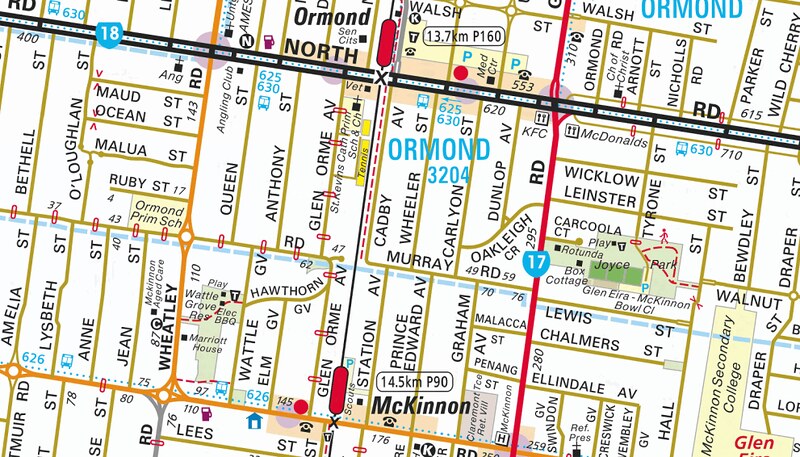
Murray Road sits midway between Ormond and Mckinnon stations, which is one of the longest sections of track in this area that has no crossings.
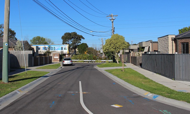
While the road has the same name on both sides of the railway line, it appears the road was never joined, or perhaps it was joined only before the railway line was built in about 1880.
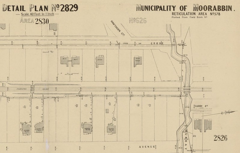
The history is hazy, but I’ve heard numerous accounts (including a blog commenter) of a pedestrian underpass having been there in the past — possibly an informal crossing which was really part of a creek/flood plain running underneath the tracks, which is clearly shown in this MMBW plan of the area.
Apparently the underpass was filled-in in the 1980s when the third track was added, and any trace of it has since disappeared, with the local roads having been fully sealed over the top, and houses built right up to the line on the western side.
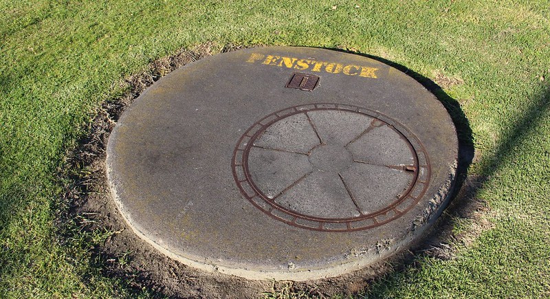
The only real indicator I could see is a small park on the western side with obvious water-related infrastructure present, with manhole access to pumps, floats, vega and penstock.
(What is a Penstock, anyway? Oh — Wikipedia says it’s a “a sluice or gate or intake structure that controls water flow, or an enclosed pipe that delivers water to hydro turbines and sewerage systems.” And a vega? It might be this: “a meadow located within a forested and relatively small drainage basin”.)
Because of this underground water and the pipes that carry it, the level crossing removal project has to build the line back up to street level between the new Ormond and Mckinnon station underpasses. And this appears to be the key problem in providing a pedestrian crossing.
Above, between, below?
Not unreasonably, the government doesn’t want to build at-grade pedestrian level crossing. The project is focussed on removing level crossings, not building new ones. In fact there’s a government policy of not providing new crossings, and the project team says the only way it would be done is if the Minister for Public Transport specifically approves it, based on advice from the relevant authorities.
The safety record for at-grade crossings isn’t great, though it seems to me the big problems occur where they occur on busy streets, particularly in busy shopping centres and adjacent to railway stations.
Putting in an overpass appears to be problematic, with issues of privacy from views into back yards, and a lack of space to build ramps that would be required to make such a structure accessible. The project team says acquisition of public and private land would be required.
But what about an underpass?
Space is tight, and DDA (ramp) access is obviously an issue, but some local campaigners believe it should be possible to provide an underpass alongside the existing water pipes, either parallel or at an angle across the line.
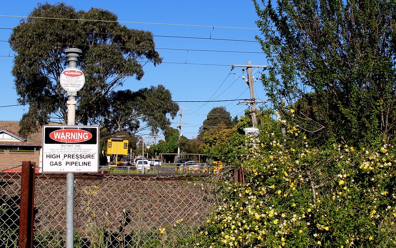
Apart from the water pipes, there’s also a high pressure gas line somewhere there, and the project team says flooding would be likely to be an issue, with installation of a flood wall being necessary.
There might be impacts on the eastern (Cadby Avenue) side of the line, but this could be an opportunity to use a traffic-calming road chicane to slow down cars — chicanes are common around Glen Eira, with several in nearby streets.
There are concerns that an underpass might have to have blind corners, reducing visibility and safety. But these are not an insurmountable problem — mirrors and effective lighting can be used to improve visibility.
Theoretically another option would be to lower the rail line at this point instead, but the project team says that too would not be practical due to the cost of relocating services, particularly the storm water drain.
Why would a crossing be useful?
To the west, Ormond Primary School is on Murray Road. To the east, there is Joyce Park and the northern end of Mckinnon Secondary College. And in fact a few years ago, a pedestrian crossing on Jasper Road was built close to Murray Road.
Providing an east-west route on that alignment would bring a vast improvement to mobility for those walking or cycling in the area, and is likely to reduce car use for local trips which are currently impractical on foot.
It would certainly be a lot safer for cyclists, who currently have little choice but to use the nearest main roads. North Road is a traffic sewer, with no bike lanes. Mckinnon Road is quieter and with bike lanes, but as local member Nick Staikos noted recently, narrow bike lanes that are full of parked cars aren’t very useful as bike lanes. Mckinnon Road doesn’t actually have a great safety record — there have been multiple bike vs car accidents recently.
What the outcome will be isn’t really clear. One would hope the project team are doing their best to explore every option to see if a crossing of some kind is possible.
A huge project like a grade separation shouldn’t be planned in isolation.
This has the broader point about level crossing removals having a big (positive) impact on local communities, and that they should be considered as part of broader transport and land use planning for these areas.
No doubt there are similar cases right across Melbourne, where grade separation should provide an opportunity to provide more places to get under or over the rail line, to improve amenity and access.
Notably, none of this would be a problem if the line was being elevated. Perhaps that was never going to happen here, given the housing in close proximity to much of the rail line and the North Road (rail under) plans having progressed well before the decision to include the other two crossings, but there are some clear lessons here for other locations.
- Petition: Re-connect Murray Road for pedestrians! Ormond and McKinnon residents are calling for a Murray Road pedestrian crossing to be included within the level crossing removal program at North Road and McKinnon Road.
- Moorabbin Glen Eira Leader: Call for safer pedestrian crossing at Murray Rd between McKinnon and Ormond railway stations
14 replies on “The Murray Road conundrum: can a crossing be provided?”
That people crossed the line at Murray Road is shown by the 1945 aerial map of Melbourne available from the Uni of Melbourne (http://www.lib.unimelb.edu.au/collections/maps/historical/1945melb/l_sheets/849c1c.jpg). Note the well defined foot tracks leading west to Murray Road and southwest to Hawthorn Grove. Access across the railway was clearly under the bridge provided for the north branch of Elster Creek. This would have been a purely informal crossing.
I’m sure this bridge was removed well before the triplication in 1987. I don’t remember it during the triplication works. I’m sure I’ve seen a reference to its replacement in the ARHS Divisional Diary – which would mean prior to 1972. Of course, I can’t find the reference now :-(
When the bridge was replaced, I wonder if they took legal steps to extinguish any prescriptive easement created by informal use of the bridge to cross the line? In Victoria a prescriptive easement is (or was) created by ‘long use of a right over neighbouring land […]. The use must have been without force, without secrecy and without the permission of the landowner for a continuous period of 20 years or more.’ (http://www.lawreform.vic.gov.au/sites/default/files/EandC_Final_Report.pdf p21). The aerial photo shows that the foot tracks were well established in 1945, and were probably used up to the replacement of the bridge say in the early ’70s.
Although you don’t mention it, I’m sure one issue is that the PTV would be sensitive to the flooding risk east of the line. About four years ago a flood after a cloudburst resulted in water above floor level to houses in Cadby and Station Sts. I’d suspect that a modern risk analysis would require any work on the waterway to provide for an increased water area, increasing the costs yet further.
@andrew, thanks – interesting that the underpass may have been gone for some decades.
Yes, the LXRA is very sensitive the flooding risk. They’ve said a key part of the design is to not make the drainage any worse than it is now. (To be fair on them, doing major works to improve it would really be a water authority role.)
Depends on the cross section of the waterway and how it changes.
The fact that there was significant flooding immediately upstream of the railway indicates that the cross-sectional area of the culvert through the railway was insufficient to carry away the water. But if the drain downstream of the culvert is no bigger than the culvert, increasing the railway culvert cross-section would have no effect on the capacity of the drain and hence on the flooding.
So, if the culvert is a pinch point, flooding is PTVs responsibility. If it is not a pinch point it is the drainage authority’s responsibility.
(As an aside, about six months after the flooding the responsible authority closed and dug up McKinnon Rd to replace the almost invisible bridge where the creek passes under the road. In doing so, they revealed that the old bridge had been propped up with industrial scaffolding. No doubt the authority had decided that 1) the scaffolding could obstruct the flow of water (particularly if debris got caught in it) causing flooding, and 2) if the scaffolding was then washed away the bridge might collapse.)
I guess the question is the cost. To travel to the unjoined Murray Road bits is just over half a kilometre. Before spending a significant amount of money, a predicted pedestrian would really need to be undertaken. A friend lives in the northern part of Glen Orme Avenue and while it is some time since I visited, I seem to recall that it was easy enough to cross the railway line behind their house, after looking to the left and right, of course.
@andrew, some material about the 2011 floods: https://gleneira.wordpress.com/2011/06/01/waiting-waiting-waiting/
@Andrew, it’s about 500 metres each way, or 1km total, whether you go via North Road or Mckinnon Road.
Crossing the tracks other than at an actual crossing is never advised, especially with 3 tracks, and in fact there’s enough fencing at Murray Road to indicate to me that people don’t do it. As well as being dangerous, it’s also completely impossible with a bicycle, wheelchair or pram.
A 1km walk is fine for an able-bodied person, but of course people are not just walking from one side to the other, it’s part of a longer journey. I gather some work is being done to determine for instance how many Ormond Primary students live on the eastern side, and how many Mckinnon Secondary students live on the western side.
On my railway line (Sandringham) there are numerous pedestrian crossings, some with automatic gates/warning tones and some without. Could the former type of crossing be installed at Murray Road? I can’t see that it’s too expensive
@Roger, that’s discussed in the paragraph pondering an “at-grade pedestrian level crossing”.
In addition to the relocatiion of underground services being costly, dealing with natural issues such as water table, groundwater flows and unfavourable soil conditions can add enormous complexity and cost. I do hope LXRA learns these lessons, and considers the elevated (viaduct) rail alternative for the Mentone to Frankston section – if it ever happens.
Thanks a for the well-presented article Daniel.
I’m not surprised this idea keeps coming up – it’s a classic “BBQ stopper” for people leaving anywhere nearby – especially families with school children that could make use of it every day and keep away from the increasingly dangerous North and McKinnon roads. And of course when those parents don’t have to drive to the schools, congestion is further reduced on the roads and at the schools. But also just anyone living in the community that appreciates openness and connectedness loves ideas like this. Indeed, at the information evening at McKinnon High in July, members of the project gave genuine support for the sentiment.
Certainly you’re right that a natural existing corridor runs right along Murray road, across the new pedestrian lights, though Joyce park and up to the rear of the high school. More students using this would mean less kids in harm’s way on the major roads and more bikes off McKinnon road which – as you say – effectively has no functioning bike lanes at school start and stop times.
I agree that the overpass solution here is a non-starter but the underpass sounds promising – as you say there are ways to deal with any concerns and we have to keep in mind the bigger picture of vastly improved safety by directing children, cyclists and pedestrians away from the increasingly busy and fast major roads.
In the same way I would hope the at-grade crossing gets a good hearing as well. To obediently defer to a black and white policy does us all a disservice. As you say the safety at a point like this with broad straight view lines in either direction at the peak of the apex provides a perfect view in either direction. Additionally, signalling could be added to the gates to add even more safety. And again – the overall safety increases when this crossing is installed. When a child is injured or worse on McKinnon or North road, no one will be consoled by saying ‘well at least we followed that rule’.
I think you nailed it with your final point about the need for a broader planning view. Yes, the government is to be commended for the speed of this project, but consideration of this broader view of all forms of transport and land use is critical and will be the lasting legacy for local residents.
As per you previous post the Project is clearly open to thoroughly investigating positive changes even if they come at some cost (new access at Ormond station, Dorothy ave). I believe solving the Murray Rd “conundrum” is not about cost or finding a solution, but having the will to do it. The best solution is just waiting to be implemented.
I wonder if the community should be told the cost of a pedestrian underpass, like the one at Lynbrook station, just to get reactions?
[…] Road pedestrian/cyclist crossing — local campaigners are continuing to fight for this, but the presence of a storm water pipe means the project team says the only viable solution is an […]
[…] Unfortunately no additional pedestrian crossing points or access or is currently planned. […]
[…] (And if you’re wondering, the rail line will come back up to street level between Ormond and Mckinnon, to get over the water pipes at Murray Road.) […]
[…] people want a crossing at Murray Road, midway between Ormond and Mckinnon. For now, there is one, for loading up more trucks. This is […]