Good news! The State Government (and our new Public Transport Minister Gabrielle Williams) this week announced the introduction of real time V/Line train info.
The caveat? They dance around it in the press release, but real time departure info is currently splintered across multiple web sites and apps.
Depending on mode, some information is available on Google Maps and other third party apps, but not yet available on the PTV web site or app.
From a quick look:
| Metro trains | Yarra trams | Buses | V/Line trains | V/Line coaches | |
| PTV web site and app | Yes | Yes | Yes | No | No |
| Google/Apple Maps/etc | Yes | Yes* | Yes* | Yes | No |
| Metro web site and app | Yes | ||||
| Tram Tracker web site and app | Yes | ||||
| V/Line web site and app | No | No |
Some bus operators such as Ventura also have web sites including real time info for their specific routes, showing the buses on a map, something the PTV app can’t do.
The Tram Tracker app can tell you what type of tram is coming (and whether it has aircon or not), and has a function to track the tram you’re on by the tram (not route) number – also not possible on the PTV app.
Bus and tram accessibility information is also inconsistent between apps.
Data accuracy
I’ve found the quality of the real time data isn’t perfect. I haven’t done an exhaustive survey, but tram data is based on interpolation between a limited number of fixed points along the routes, and accuracy of the other modes, especially buses, has been notably mixed.
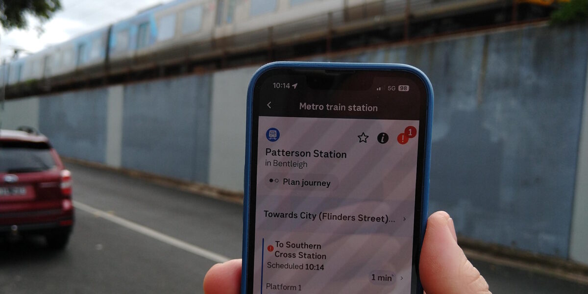
Even beyond that, you’ll find some discrepancies – for instance the screens at the entrance to Patterson station are frequently missing some departures.
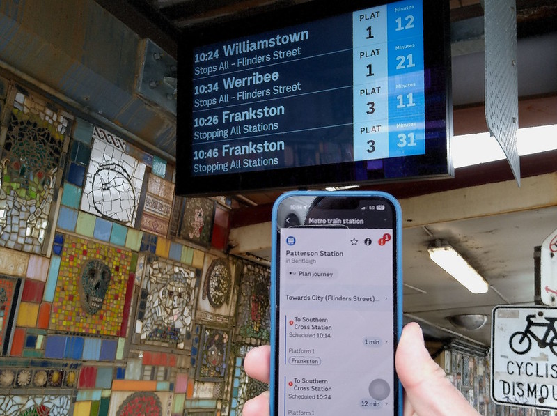
It appears some discrepancies are deliberate – trains disappearing off the screens at the entrance to CBD stations a minute or two before they’ve actually departed. But Patterson doesn’t seem to be one of those.
So the real time information is very useful, but you can’t necessarily depend on it being 100% accurate.
How busy?
Apart from live departure information, passenger load data is also available. It started on a dedicated web site (Ridespace) but moved to other services such as Google Maps and Apple Maps too – though only on the apps – it’s not on the Google Maps web site. It’s still good to have… though most or all of it appears to be based on historic patronage data, not real time feeds from vehicles.
Why are real time departures available to some apps/web sites, but not others? My guess is that V/Line is providing theirs in GTFS Realtime, but PTV and V/Line’s own apps can’t ingest and display it yet.
So in summary, there’s real time info out there for most PT in Victoria, but right now, your best bet is third party apps from Apple and Google and the like, not the official ones.
Still, there’s progress.
Real time info isn’t a substitute for reliable or frequent service, but it helps.
Hopefully they’ll keep making enhancements so that accuracy improves, and making it all available on the PTV app, which also has the ability to read and top up Myki cards.
And of course there are challenges still to conquer: tracking bus replacement services, and fully integrating journey planner, disruption and real time information together – so the planner can plot your journey around live disruptions, and tell you how busy it’ll be.
9 replies on “More real time PT info now available”
As we are going to travel by train from Melbourne to Sydney, last week I started looking at the XPT service between the cities. One day the Melbourne bound service broke down at Seymour and was delayed for over three hours, meaning the train wasn’t at Spencer Street to make the 8.30 departure to Sydney and travellers were put onto coaches for the whole journey. The NSW train website was a little helpful but I first noticed the problem with the anytrip app. Anytrip is far from user friendly and at times completely fails. To monitor the XPT in Victoria I had to change to the NSW location.
I know we are on the cusp of getting good and reliable information but I fear I will be too old to take advantage of it, which is infuriating as I know the technology is there.
Btw, a few weeks ago I was waiting for a Pakenham/Cranbourne train at South Yarra to travel directly to Melbourne Central. The train was running late and changed to a Flinders Street service. I left the train at Richmond to wait for a City Loop train. In less than two minutes, another Flinders Street service arrived and in less than two minutes after, a City Loop train arrived. I was amazed and I think the trains were using the new in train signalling system, as I can never remember seeing trains so close together in Melbourne.
Yes, the Pakenham and Cranbourne lines are trailing CBTC (Communication Based Traffic Control) signalling with an increasing number of trains using it.
I thought CBTC only covered South Yarra to Clayton – wasn’t the inner section left with conventional signalling (since the HCMTs won’t go there from 2025).
For the XPT, I’ve found it’s possible to track it via the NSW Trainlink web site, but you have to go through the booking pages to do it (look for a train, don’t make a booking) – I haven’t found a way to just see the live status.
i thought the inner had to be too if they wanted to use it on the outer (otherwise the trains would need to space out more once getting to hawksburn… which isnt going to be possible without running them spaced out on the whole line.
I noticed that trains-disappearing-from-big-screens-at-station-entrances thing the other day, when at Parliament the sign at the ticket gates said I’d be waiting 15 minutes. When I got to the platform a minute later, the next train was due in 7 minutes. So I think they’ve overcooked their we-know-best display manipulation there.
In London, we found the Citymapper app to be excellent. It had all the real-time info and it warned us *clearly* when a trip would be on a replacement bus or similar (unlike the PTV app). But in Melbourne we found it didn’t have real-time data. I just tried Citymapper for a trip from Lilydale to Tooronga, and it did show an orange warning about service interruptions. However, instead of saying “replacement bus between Lilydale and Ringwood”, it produced (after I clicked it) a wall of text. I kid you not – about 500 words of guff talking about rail projects and using PR phrases, none of it including information about there being buses replacing trains RIGHT NOW.
It seems clear that there is still not a reliable source of service information, and all of these apps must be relying on significant human intervention to make them work.
@David, I think (from looking at an old diagram) the conventional signalling for the inner section already allowed a higher frequency than further out. I doubt they installed CBTC between South Yarra and the City knowing it would only be used for 2 years.
Also can’t find it right now, but a recent govt doc specifically mentioned South Yarra to Clayton.
The conventional signalling is such that you can get trains very close together at places like Richmond: see this pic from 2008: https://www.flickr.com/photos/danielbowen/27228618378/
@Philip, I’m not surprised Citymapper had a wall of text about a bus replacement. All the apps use the same public data feeds, so that’s probably what PTV dropped into it.
The timetable data does take into account bus replacements (including for journey planning) but it’s not live data. I think Ventura does the tracking when it’s their buses doing the services, but the others don’t – and it’s not integrated into other apps.
How do VLine trains get real time crowding data? I know some metro trains have weight sensors, but I’d be surprised if the old loco-hauled carriages can do that.
Well, it’s good that real time information is improving, but one problem still seems to to be with the in-train information. Earlier this week I was on a Siemens train on the Frankston line, and for the entire journey both the auto announcements and in-train displays stated it was going to Laverton. But at Flinders St, it pulled into platform 13, and the next auto announcements stated that it was going to Sandringham. Surely Metro knew that this was going to occur before the train arrived at Flinders St? And a specific announcement (along the lines that the train wasn’t going to go where we had been told it would) to alert people unfamiliar with the strangeness of Metro would have been nice at Flinders St.
I caught a Sunbury train from Platform 12 at Flinders Street the other night. Surely only people who catch Sandringham trains know where Platform 12 is!
I’ve just realised that I can use the realtime information in the PTV app to determine whether I get off my train from Geelong at Sunshine or Footscray to get the best connection to West Footscray – now that I don’t need to game the fare system.
My more-often-than-not usual morning train is the 9.13 from West Footscray to Sunshine – which pretty much never runs on time so I usually miss the 9.23 from Sunshine to Geelong (although this morning Metro and V/Line coordinated their late-running trains). Anyway, I usually have a laugh when the 9.13 is six minutes late it arrives at West Footscray at the same time as the announcement that the 9.19 has been delayed… “but here’s a train you can catch instead!”
Bring on realtime information in the V/Line and PTV apps!