Last week the State Government announced another ten level crossings to be removed, on the Pakenham, Frankston, Mernda, Sunbury, Lilydale and Belgrave lines.
This made sense in part because they want to keep the workforce busy once other projects are completed. Leave it too long and those skilled people will move elsewhere, and you can’t get them back for the next tranche of projects.
Crossing-free
What’s pretty cool about this is that when these (and the others already pledged) are done, the Cranbourne/Pakenham and Lilydale lines will be completely free of road level crossings – though there will still be some pedestrian crossings.
Unfortunately while there’ll be no crossings on the Lilydale line, there will still be single track at the outer end, so the capacity limitations and delays this causes won’t be resolved. This seems like a missed opportunity.
Happily they are duplicating lengthy remaining single sections of the Cranbourne line as part of grade separation projects.
Generally, the closer to the City, the busier the trains and the roads. So delays and disruptions due to single track and level crossings (be it from heavy rail traffic, or incidents) tends to affect more people the closer in it is.
So then, once all current projects are completed, how much single track will be left, and where will the innermost crossings be?
Here’s a comparison in map form: 2021 (left) vs 2025 (right):
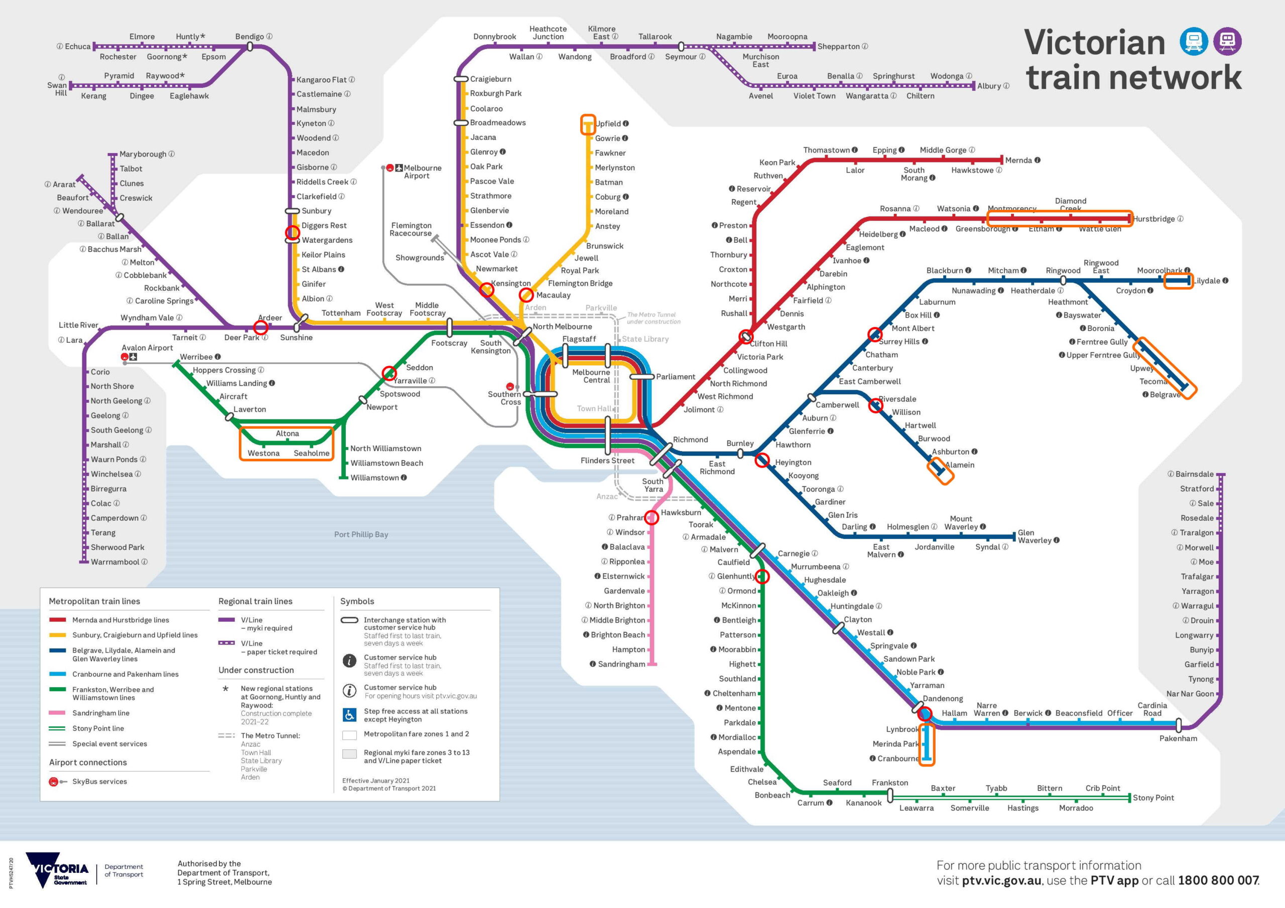

- Red circles are the closest crossings to the City
- Orange shows all single track on the Metro network (Some of the stations on single track sections have passing loops). Sorry, I haven’t done V/Line sections.
- Base map is the official PTV map.
If you want it, I’ve also put the same information in a table.
Click to view table
| Line/s | Closest crossing now | Closest crossing 2025 | Single track |
| Altona/ Werribee/ Williamstown | Anderson Street, Yarraville | same | Most of the Altona Loop |
| Geelong/ Warrnambool | Fitzgerald Road, Ardeer* | via Wyndham Vale: Wests Road, Werribee via Werribee: Browns Road, Werribee | Mostly single track beyond Geelong, to Warrnambool |
| Ballarat/ Ararat | Fitzgerald Road, Ardeer* | Hopkins Road, Rockbank | Some single track beyond Melton, to Ballarat and Ararat |
| Sunbury/ Bendigo | Calder Park Drive* | Watsons Road, near Diggers Rest | Some single track between Kyneton and Bendigo |
| Craigieburn/ Seymour/ Flemington Racecourse | Macaulay Road, Kensington | same | Some single track between Tallarook and Seymour |
| Upfield | Arden Street, North Melbourne | same | Gowrie to Upfield |
| Mernda/ Hurstbridge | Ramsden Street, Clifton Hill | same | Greensborough to Hurstbridge (being partially duplicated) |
| Lilydale | Union Road, Surrey Hills | none | Mooroolbark to Lilydale |
| Belgrave | Union Road, Surrey Hills | Alpine Street, Ferntree Gully | Ferntree Gully to Belgrave |
| Alamein | Riversdale Road, Riversdale | same | Ashburton to Alamein |
| Glen Waverley | Madden Grove, Burnley | same | None |
| Cranbourne / Pakenham | Webster Street, Dandenong | none | Dandenong to Cranbourne (fully duplicated by 2025) |
| Gippsland | Webster Street, Dandenong | Koo Wee Rup Road, Nar Nar Goon | Some single track between Bunyip and Bairnsdale |
| Frankston | Neerim Road, Glen Huntly | Wickham Road, Highett | Single beyond Frankston, to Stony Point |
| Sandringham | Greville Street, Prahran | same | None |
Have I made any errors? Let me know in the comments.

Single track
Single track limits the number of trains that can run, and causes delays to snowball.
Even post-2025, there’ll still be sections of single track on the Altona Loop, Upfield, Lilydale and Belgrave lines. The Hurstbridge line will have some sections duplicated, but still have some single track. (There’s also been recent progress on the Ballarat line.)
As with crossings, the effects of the single track are reduced as you get further from the City, but with Melbourne ever-expanding, these do need to be resolved – especially the Altona Loop and the Upfield line, where cancellations and diversions leave long waits between services.
Crossings post-2025
Once completed in 2025, many lines will have their inner sections completely separated from motor vehicles. This should help a lot with the impacts of motor vehicle vs train accidents.
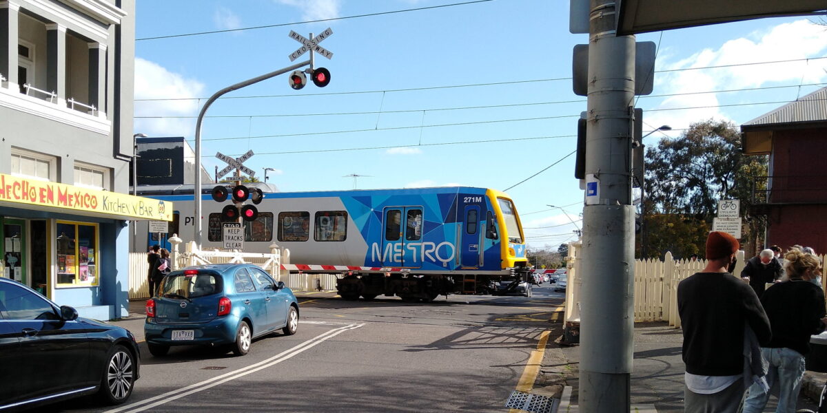
Notable inner-city crossings remaining will remain at Clifton Hill (not too much traffic, hopefully lower risk than some), on the Sandringham line (which has received no removal projects whatsoever), Madden Grove on the Glen Waverley line (perhaps the busiest road crossing remaining in Zone 1), Macaulay Road on the Craigieburn and Upfield lines, and several more on the Upfield line. Also several on the busiest section of the Werribee/Williamstown line – including at Yarraville (lead image for this post) and Spotswood where there was a crash just a few weeks ago.
By 2025 when the Metro tunnel opens, the Sunbury line will almost be crossing free. Just two left on the outer section of the line between Diggers Rest and Sunbury. The government says it may be difficult to justify the cost of grade separating these: Watsons Road is a quiet country road. Old Calder Highway looks a bit busier.
Maybe in a few years they’ll look at these? Zero crossings would be a prerequisite for driverless trains, though there are other significant barriers, including much of the line from Sunbury through to Cranbourne/Pakenham being shared with V/Line and freight.

Significant progress
It’s actually amazing to think that by 2025 the number of crossings in Melbourne will have been roughly halved. When the 2009 ALCAM study was done, there were 180. Removal of 85 is now committed, a reduction of 47%. This would have been unimaginable not too long ago.
It’s an expensive program, certainly. There are benefits for everyone – though this would be an easier sell if some lines didn’t repeatedly miss out on getting new stations (hello to you, Werribee line).
Still, great progress. Whether it keeps rolling may depend on the 2022 State Election. With Labor said to be wanting to fight this on infrastructure, you can bet more crossings will be pledged for removal. Hopefully this includes the rest of the worst – but hopefully they also continue to address more single track sections – and of course better implement service upgrades to go alongside these infrastructure improvements.
33 replies on “More crossings to go”
The poor, unloved Alamein line! After 2025 it will almost certainly still have both single track past Ashburton and as well as a level crossing (with tram square) at Riversdale. Can’t ever see Riversdale LX being removed.
ALCAM didn’t include all the pedestrian crossings around the network; including those pits the percentage at far less than 47%.
I counted about 149 heavy rail crossings in Melbourne (pedestrian and/or occupation, not public road) that will still be open in 2025, plus a further 30 on the light rail system, though I might have missed some.
*including those, the percentage…
@Daniel I’d be interested in your opinion which remaining crossings should be the focus of the next batch after the current 85.
There is also the single track section at Williamstown, if one wanted to really nitpick.
It was a bit disappointing they didn’t use the chance to duplicate the Upfield line when the Camp Road crossing was being removed a few years ago.
The single track section at Alamein is really no big deal. Trains can terminate simultaneously at both Ashburton and Alamein if needed, and with that single track section you could still easily run 10tph to Alamein which is way overkill.
I believe you may have got the location of the Glen Waverley line # Glenferrie Road tram crossing in the wrong place on your maps. It’s at Kooyong station (and is my nemesis as I travel from Fairfield to Malvern to visit my mum).
Leaving your Labor/Greens bias aside, I agree the crossing projects have been welcome in removing the number of crossings in total. The other missed point is the severe lack of future planning with regards to the Skyrail projects. The Dandenong corridor stuck at 2 lines again and the proposed Parkdale project with 2 lines is not moving forward to allow a separation of freight and country traffic from Metro.
Ripponlea is missing. Annoying when lined up on the western side but can be *diabolical* when on the eastern approach.
@David, I wouldn’t be surprised if there’s an ALCAM document somewhere which evaluates all the pedestrian crossings. (Remember, the list of road crossings only made it into the public sphere by accident)
@Benjamin, true – Williamstown and Sandringham both have short sections of single track and a single terminating platform.
@Phillip, that was incredibly disappointing.
@John.S, good point – Alamein duplication isn’t a high priority.
@Brian, sorry, for clarity, the red circles aren’t showing every crossing; they’re showing the closest crossings to the City on each line.
@Bobman, the govt was focussed on capacity, not speed. Better signalling longer trains means the Dandenong line capacity will be far higher than it was in the past. They also didn’t want 4 tracks because it would have involved lots of property acquisition. It was a hard enough political sell without also demolishing lots of homes.
@Noam, see reply to Brian.
@Brian The Glen Waverley level crossing in the map is Madden Grove between Burnley and Heyington.
@Bobman I’m pretty sure there is enough of a reserve to add new tracks parallel to the Dandenong line where skyrail exists. I agree that a 3rd track should have been explored in the scope of the project, but it is still something that can happen as demand increases.
IMO, the biggest missed opportunity was not duplicating the Upfield line. While it would not increase the number of services right now due to bottlenecks with the rest of the Northern lines, it would significantly increase service reliability.
I like the slider to compare nearest crossings to the city now vs in 4 years time – how did you do it? 🙂
Ramsden St, Clifton Hill may be low in road traffic, however it is on of the highest rail traffic level crossings (almost certain to be in the top 3, all the time passenger services are running, once the Mont Albert and Surry Hills grade separations are done).
Firstly, in a recent meeting of the SRSV (Signalling Records Society Victoria), there was mention that, they where working on another 25 level crossing removals. This announcement, I presume is 10 of that 25.
Which ones make up the other 25, I do not know. Is their announcement due soon???
It is getting to the point that, removal of crossings is pointless. Given we would only have relatively low use crossings left on the network.
On the matter of the Narre Warren project, me being a local, have some feedback on that matter.
#1, There has been recent plans, to close off the road at the crossing, and convert that block into a mall. This was to correspond with a project to open up access onto the nearby Cranbourne road, to replace this current connection. This plan, would no doubt make the Webb Street crossing redundant.
#2, Most of the congestion in Webb Street, comes from through traffic, that would be better diverted onto the Cranbourne road route. The big issue is, the corner of Webb Street/Srives road and Center road. Many of the locals are keen to have a road bypass around this bottleneck, of which would also divert the majority of ‘through traffic’ away from Webb street, and onto Cranbourne road.
Further to this is, the crappy signalling system, which does not track the trains, and, distinguish between which are express and local. This simple change, would reduce delays at many of these crossings by a very large amount. Down to just 20 to 30 seconds plus the passage of the train, not, two or three minutes while waiting for a local stopper as what happens today.
If I can add my nit pick… Ashburton station should be inside the orange box. The dual track begins just north of the station. If there was a need to increase frequency on the Alamein line, then they only need to add a few hundred meters of track and a second platform at Ashburton
All very interesting. I instinctively thought those very short last sections of single track don’t matter much, but then I remember when we lived opposite the signals where trains would wait before an inbound train from Alamein cleared the single track, waiting between Ashburton and Burwood Stations and it occurred to me that there would people on the train stuck there waiting to get to Ashburton and Alamein Stations. It was not at all unusual for a train to be sitting at the signals. There is a good chance they had to change trains at Camberwell as well., another subject.
How many billions would it take to remove level crossings on the Sandringham line? The level crossings are generally at quiet streets or traffic calmed shopping areas. Aside from perhaps the South Road crossing, it would not be money well spent.
The Spotswood crash is interesting. I will assume the van driver stopped on the tracks because he was blocked by traffic ahead, and then his van stalled and he could not restart it. So he went onto a railway line without it being clear on the other side. At least he was smart enough to bolt from his van, if not smart enough to not stop on train tracks. It would be rare to have any legitimate excuse to get hit by a train on a level crossing.
McCauley Road X 2 and Madden Grove should be added to the list.
Why not just close the Ramsden St, Clifton Hill crossing? There is an alternative under rail bridge road crossing very close by (Roseneath St) and pedestrian crossing via the station underpasses.
@Andrew
I use the Upfield line and it would be impossible to remove the Macaulay Road level crossing. It would have to remain intact. You cant do rail or road over because the Citylink Freeway Viaduct is right above the Upfield line, you can’t do rail or road under because the Moonee Ponds creek is in the way. Closing the crossing would be a massive inconvenience because its a very important thoroughfare in that area with industrial traffic and the bus routes that use that road.
Madden Grove is a little tricky due to the CityLink interchanges and bridge traffic over the Yarra. I wonder if you could simplify things a bit by making Burnley St northbound only between Barkly Ave and Swan St (currently single lane in either direction), and make Madden Grove / Loyola Grove southbound only between Swan St and Twickenham Cres. Then they only have to build a two lane road bridge(?) instead of four.
In the before-times, I used to dread having to cross Loyola Grove on foot to/from the Main Yarra Trail, two lanes in each direction and several roundabouts made it nearly impossible to cross at busy times unless you diverted to the lights at Gibdon St.
(And one more wishlist item that nobody will do anything about while I’m at it, I wish there was a direct way to cross from the Gardiners Creek trail to/from Heyington station and surrounds without trespassing through St Kevin’s).
I’d be interested to understand whether there would be savings in terms of dollars, time and inconvenience if more removals were grouped and undertaken at the same time. For instance, surely it would have been better for the Croydon & East Ringwood removals to have been undertaken at the same time as Mooroolbark and Lilydale. Ditto Bell, Preston & Keon Park when Reservoir was done. I’m hoping to see future announcements preference a number of removals on a section of a line, rather than individual removals dotted across the network.
And Bobman, absolutely agree re additional tracks between Dandenong & Caulfield. What a missed opportunity to substantially boost capacity for VLine services to Gippsland and freight to Gippsland and Westernport.
There are actually 92 level crossings to be removed, not 85.
84 are grade seperations (including the relocated grade seperations for Thames Promendate in Chelsea and McCleod Road in Carrum), and 8 are closures.
If you count the list on the LXRA website (https://levelcrossings.vic.gov.au/projects), you’ll get 91, and then you need to add one more because Park Road for some reason isn’t seperately listed from Charman Road.
The announcements have been a bit haphazard, especially for closures.
Park Road wasn’t ever listed in the original 50 or subsequent 25, despite being a grade seperation and not just a closure. But then Eel Race Road was on the list for grade seperation but ended up being a closure.
Mascot Ave (closure added to the Carrum project) and Lochiel Road (closure added to the Edithvale-Bonbeach project) didn’t ever get announced as part of the original 50, subsequent 25 or recent 10.
But then Swanpool Ave was included on the subsequent 25 list depite being a closure: https://levelcrossings.vic.gov.au/media/news/More-level-crossing-removals-on-the-way
Finally, the recent announcement of 10 is actually 10 grade seperations plus 4 closures: https://levelcrossings.vic.gov.au/media/news/10-more-level-crossings-to-go-by-2025
So with 92/180, the removal of crossings by 2025 will actually pip over the 50% mark!
And they only need to remove 8 more to be able to say they’ve removed 100.
Agreeing with @Guy that closing the Ramsden St crossing at Clifton Hill might be the best option. Only issue is that the government might (one hopes) look into better pedestrian and bike links, whether by underpass or overpass, for residents on the east side of the station to get to the west side where the main commercial area of Clifton Hill is.
Really, the government should have had a more comprehensive plan when they duplicated the track between CH and Westgarth (and got rid of the crossing at Westgarth station, too!) over a decade ago now, but here we are…
@Daniel You don’t mention the crossings listed for simple closure, which has flown under the radar with this latest announcement.
@Rohit, 3rd tracks tend to be out of favour, because they only allow extra trains in one direction, which requires inner-city stabling capacity. Four tracks in general is better.
@Michael, the slider is something I just noticed in WordPress. I think it’s part of the Jetpack add-on.
@Rod, fair point. Given the current Alamein track arrangement allows trains every 15 minutes, I suspect that’s plenty for now.
An alternative would be every second train terminating at Ashburton.
@Andrew, good point – Hampton Street and South Road are perhaps the only very busy arterial roads on the Sandringham line. Bay Street and Church Street and Glen Eira Road are a little bit busy, but not exactly major arterials.
@Tim, I would love to see savings delivered by batching crossings. You’d assume there are savings at least due to reduced bus replacement costs.
One reason they don’t always do it is because many projects require extended road closures, and they don’t want to close multiple roads all close to each other… it can cause big traffic problems.
@Dgusten (and Anthony Y), good point on the closures. To my mind, many of them make sense. The current road network is not always the most logical, so it makes sense to consider those options.
Nice update Daniel! Unless I’ve missed something, the closest Sunbury line road crossing to the city is actually at Old Calder Highway, Diggers Rest (adjacent to the station); Watsons Road being somewhat to the north / on the down side of Diggers Rest station
For those hoping that the Lilydale line will be duplicated, it’s in the too hard basket right now, and even if it was duplicated, it would have next to no improvements in the timetable due to the Lilydale/Belgrave shuttle system at Ringwood.
Money actually needs to be directed towards duplicating the Belgrave line to Upper Ferntree Gully, not because of absurdly high patronage in semi-rural areas on the side of a mountain, but to get trains out of the way of each other, since the government absolutely requires as many trains as possible to serve as many stations as possible.
This would also require grade separation of two level crossings as well as replacing a bridge so it will be expensive, but nowhere near as bad as trying to duplicate the entire line to Belgrave, especially around Tecoma where there is literally no room without a lot of earth works, replacing a dozen or so bridges, and straightening out the curves to fit a dead-straight two-platform station (Tecoma is curved at the down end and there is absolutely nowhere else to fit the station due to the line having so many curves).
Only once this is done, the side effect of being able to run More Trains More Often™ can happen on the Burnley group as a whole (yes, even the Alamein line).
Trains to Belgrave take about 30 minutes from Ringwood, whereas trains from Lilydale take about 20 with a 10 minute wait so it doesn’t beat the Belgrave train when they both arrive at Ringwood (one being a shuttle).
If every second train could run to Upper Ferntree Gully at more frequent intervals (due to having no single-track bottleneck), with the 693 bus upgraded to act as a 20 minute feeder for the Belgrave section, this would let the Lilydale side run every 20 minutes as well as improving the frequency on the Glen Waverley line when those more frequent trains reach Flinders Street.
No votes behind it but the Alamein line could easily be converted to light rail and integrated into the the Yarra Trams network. Bonus is getting rid of a couple of level crossings (including the 2nd last tram square).
The next high priority level crossings to be removed should be on the Glen Waverley, Cragieburn, Hurstbridge line between Clifton Hill and Ivanhoe and the Highett level crossings on the Frankston line. I am suprised these were not chosen to be removed prior to the additional 10 selected, which are on sections of train lines that are not particularly busy (i.e Lilydale line with a low train frequency) and with much less road traffic than remaining crossings in inner and middle urban areas on the Glen Waverley, Cragieburn and Hurstbridge lines.
The unloved and often forgotten Stony Point Metro line is also single track.
@ubird69, downgrading the Alamein line from heavy to light rail wouldn’t inherently remove level crossings, at Riversdale road it’d just replace a train/tram box with a tram/tram junction. One potential advantage of light rail, greater frequency, is unlikely to be needed along this corridor which is already well served and very suburban. Locals would lose their direct rail connection to the city (as presumably the light rail wouldn’t continue into the city any further than Camberwell station), rendering the line a permanent full time shuttle, further reducing its importance and potential for growth. Light rail is great for certain environments, like replacing busy bus corridors in Canberra or the Gold Coast, but it being the latest ‘hot thing’ in transport planning doesn’t mean it’s the panacea for the ills of every rail line that’s short or a spur.
I use the Lilydale line, and am a community member of the Stakeholder Liaison Group for the Lilydale project. Truth be told, the Lilydale level crossing was fine – only one crash had occurred – and that was 15 years ago! The issue to begin with was the single track between Mooroolbark and Lilydale, causing huge delays, many of which were Lilydale trains that had to terminate at Mooroolbark – nearly 50% of Lilydale services terminated at Mooroolbark simply because there is a single track between the two stations. Another issue is that there is a new housing development on the old Lilydale Quarry which will see more than 10,000 residents – approximately 2 cars per household. The closure of the Cave Hill Road level crossing would put extreme pressure on surrounding roads in Lilydale, so it would not improve the road traffic nor the rail line. Local residents such as myself would rather have wanted to see the money for the Cave Hill crossing go towards duplicating the line and to upgrade the roads surrounding the crossing, as this crossing has very little traffic, only used by emergency vehicles and locals wanting to avoid the congested roads in Lilydale.