Channel 9 and The Age got hold of a previously unpublished rail plan, or at least the summary maps from it.
Age: Leaked rail plan shows few extra services for regional commuters
Channel 9: I assume the headline-writer got a little carried away. Metro 2 isn’t really a secret.
The stages
The staging appears to be very similar to the PTV plan release back in 2013; it’s obviously evolved over the past five years. (Let’s assume that the swap of Spotswood and Seddon is an error.)
To me it all seems reasonably sensible. Channel 9 has a good summary of the projects involved, which is well worth a read.
Here’s how things will sit when the Metro (1) tunnel opens. Dandenong and Sunbury are connected via the tunnel. Frankston takes the Caulfield Loop. Sandringham is connected through to Newport.

Also by this point, the Upfield line has been extended to Craigieburn, with Seymour/Shepparton/Albury trains using it instead of the Craigieburn line – does this mean the Albury line would be converted to broad gauge? Not sure.
By stage 4, the western portion of Metro 2 (Werribee line, Newport, Fishermans Bend, Southern Cross, Flagstaff, Parkville) is in place, as well as electrification to Melton and Wyndham Vale (planning works for these were pledged by Labor yesterday).

By this point the Frankston line has been extended to Baxter, and the Cranbourne line to Clyde. The other big change is the City Loop is re-configured to route the Frankston/Baxter line through to Craigieburn. Glen Waverley is running direct and is routed through to Upfield/Craigieburn, which has an extension to Wallan. The Airport line is in place via Sunshine, and there’s a connection from Werribee to Wyndham Vale. Laverton (Altona Loop) and Williamstown trains are disconnected from the Werribee line, and continue to run via Footscray.
Also note the annotations showing the number of peak trains. This is the catalyst for The Age’s headline. Some people on Facebook have assumed that’s an all-day frequency. It clearly isn’t — the Dandenong line is not going to have 22 trains per hour all day.
Stage 6 completes the Metro 2 tunnel, connecting Parkville to the Mernda line, which also has a branch north from Lalor to Wollert. This line is connected through to Werribee and an electrified Geelong line, with Warrnambool passengers changing at Geelong.
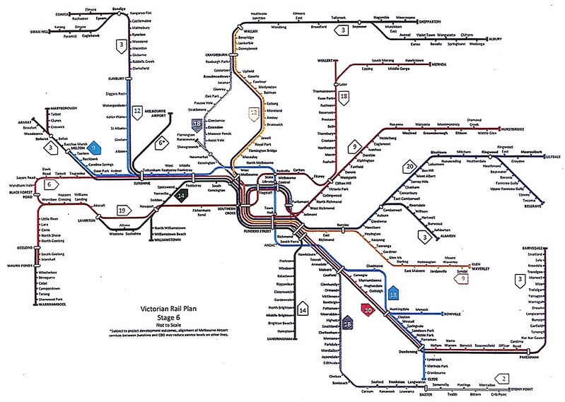
A big change here is the Cranbourne/Clyde and Pakenham lines have been separated. Clyde now runs via the tunnel, then via Chadstone, with a branch at Huntingdale to Monash Uni and Rowville. This obviously differs from State Labor’s view of light rail serving Caulfield/Chadstone/Rowville. Additional tracks from Huntingdale to Dandenong (where the alignment is wide) allow Pakenham and V/Line trains to run express. At the city end, Pakenham is connected through to Wyndham Vale, if I’m reading the fuzzy out-of-focus lines correctly.
There’s some final twists in the “Long term” vision.
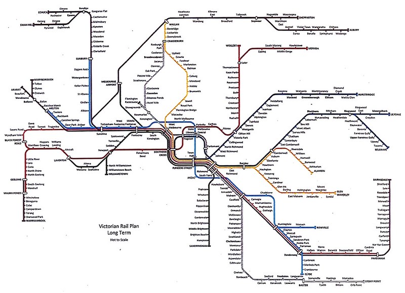
Seymour/Shepparton/Albury trains now run via the Airport instead of via the Upfield/Wallan line. The suburban Airport line no longer connects to Sunshine, but runs direct to somewhere near South Kensington – but without any intermediate stations, which seems a waste.
Also note the City Loop configuration. It appears the Hurstbridge line would run via the Loop then out to Ringwood. By this point, no metro services would terminate in the City – they’d all be connected through to other lines.
So what’s not in here?
The Suburban Rail Loop is the obvious one. It was prepared separately from the rest of this plan before being announced last month. It does have limited interaction with the main network, particularly in the east, though there’s talk of it sharing parts of the Airport and/or RRL alignments.
The other glaring omission is the Doncaster line.
The focus for service frequencies is all based on the maximum. I know there’s good work going on to move towards frequent all-day services, and you’d hope that a full plan (with explanations for these leaked maps) would detail that.
Despite the leak, I don’t expect the full plan to be released this year. But hopefully in coming years, well after the dust from the election has settled, and the bureaucrats have had time to properly digest and incorporate the plans of their political masters.
Forward planning is vital, and the enthusiasm for rail from the politicians is very welcome — it’s vital as our city continues to grow. Let’s hope that whoever wins in November, things can move forward in a coherent, logical manner.
Update: The Frankston Leader reported on the diversion of the Frankston line away from Southern Cross and Flinders Street:
Liberal public transport spokesman David Davis said the plan would “make life very tough indeed” for Frankston line commuters trying to access the southern or western side of the city.
Mr Davis accused the government of “hypocrisy” for removing the two major stops from the Frankston line after criticising the former Liberal government for a similar proposal.
Mr Davis is referring to the 2014 “Melbourne Rail Link” plan, the Coalition’s version of the Metro tunnel. But before that, the Frankston to Craigieburn plan was seen in the PTV Network Development Plan back in 2013. So he’s criticising a plan originally released when the Coalition was in power.
It’d be nice if the politicians looked at these plans on their merits rather than supporting or attacking them based on which side was in power when they came to light.
21 replies on “Rail plan leaked”
I know this might be a weird question but how would the Upfield and Glen Waverly lines be connected if the X-Trapolis trains can’t even use the Upfield line currently? Would there have to be upgrades to allow X-Trapolis trains to use the line similar to the upgrade the Frankston line had a few years back?
Further to @filly’s question, would the Craigieburn and Upfield (future, Wallan) lines be sharing stabling and maintenance facilities or would they be kept separate?
The whole idea of loop reconfiguration is interesting. They’ll have to dig a few new tunnel portals.
2 different plans released on the same day. Sounds like someone at TfV has their nose out of joint.
3 trains per hour on the Alamein line is rather under-doing it. If it was extended to through East Malvern and Chadstone SC to Oakleigh, it would be useful for far more passengers.
Presumably Doncaster has dropped off their plans given the busway proposal?
Another plan omitted would be the branch into Torquay via Armstrongs Creek? Also no sign of a train to serve Highpoint & the Maribyrnong defence site that the Federal Libs are keen on. Even if it doesn’t reach the Airport, a new line to Keilor has some merit.
As for Albury, the current network maps don’t show the standard gauge route through Albion, so presumably that would be unchanged. Shepparton trains could potentially enter Melbourne the same way with foreshadowed guage conversion as part of the current upgrade.
Later SG Seymour trains could run via Albion too, with relevant third track (or at least passing sidings) to leap-frog freights? This would seem smarter than an entire new line between Airport & Wallan.
Gauge conversion of the Glen Waverley/Alamein – Wallan line could offer an alternative route for disruptions or if they are slow to boost capacity on the Albion route.
Interesting the complete disentanglement of the City Loop – apart from the Hurstbridge and Ringwood connection. That could’ve all been done 40 years ago, with Richmond and North Melbourne being major interchanges and trains travelling in both directions throughout the whole day.
No sign of rail extensions beyond Ararat and Maryborough!
Seeing as the radial spokes of the network are basically unchanged, the orbital rail line fits exactly the same as it would currently – apart from a direct interchange at Monash. Obviously still need the detail of what happens in the western suburbs.
I would expect the detail of this plan to evolve over time, but it provides a really good skeleton of what the rail network might look like in 30, 40 or 50 years’ time.
Airport to Seymour is a good idea but I would rather it go via Craigieburn – the map is very deceptive because Wallan is actually 25 km from Craigieburn!
How are Craigieburn people meant to get to the airport?
There is an empty corridor from runway 27 to Avoca St, Broadmeadows – clearly that corridor has been left alone to allow a railway or busway to be built from airport to Coolaroo Station with minimal tunneling.
It is ridiculous how there is no station just outside the airport to allow people living in Keilor Park to catch a train!
Jacob, presumably the planners thought either Craigieburn locals would have to get a train to Broadmeadows and then onto the 901, or maybe they had assumed a direct bus might be offered? Not optimum. But now with the Suburban Rail Loop, there will be an eventual train option from Broady.
Hopefully the alignment west of Coolaroo is still on the table for the SRL
Metro 2 going via Fishermens Bend to Newport is interesting as it misses bringing rail closer to Scienceworks by a stop at Spotswood, with one end of the platform close to Spotty, and he other cloer to Scienceworks.
Also it could go further west to Altona North where a large factory site (former Dons smallgoods etc) is now vacant with plans for thousands of multistory residences to go in. So many new customers!
Also there is no score for Point Cook. Altona loop terminates at Laverton, when it could i/change there and then head to Point Cook and the future Werribee East (massive) development.
This ‘long term’ development is short term again for the West.
This plan definitely needs further work, with or without SLR becoming part of the plan.
For starters, the plan indicates virtually zero growth in services on some lines between now and stage 6, or at least beyond the opening of MM1.
The Alamein line stays at its current 3 trains in peak hour, the Hurstrbrige line stays at its current 9, the Glen Waverley line grows from the current 8 to just one more later, the Belgrave/Lilydale line grows from 18 now to 20 later.
There’s no doubt these corridors won’t grow as much others, but with Melbourne adding millions of people, at least some of the growth is going to be from increasing densities in existing suburbs, especially near train lines where multi storey blocks are already being built. More trains will definitely be required.
Growth is contemplated on the Sandringham line from the current 8 trains to 14 trains when MM1 opens (which seems a bit excessive initially), but no further growth is apparently required beyond that.
And somehow, the Williamstown and Altona lines are supposedly going to need 6 trains per hour each in stage 4. I’m actually thinking that this surely must include some trains that travel via Altona from further west. There couldn’t possibly be enough patronage on the Williamstown and Altona lines alone for 14 trains in Stage 6, with only 19 trains slated for both Werribee and Geelong.
On the east side, I like the idea from Tom the first and best, extend Alamein to intersect the Glen Waverley line, Chadstone and then connect at Oakleigh. It could terminate here, or extend to Huntingdale and out to Rowville, effectively making a Camberwell-Rowville line. With the plan for the Cranbourne line to divert out to Chadstone before rejoining the line again, it brings it ever-so-close to Glen Waverley line without connecting to it. Perhaps an Alamein extension (plus double tracking) would serve a better purporse.
Out west, I am unsure how trains coming from Albion can hang a right at Sunshine and head out west. Purely going by a map (not a local out that way), what about the SRL continuing on what looks like a goods line to Brooklyn, then follow the M1 towards Altona North, perhaps follow a trail line around Leekes Road, then to Hoppers, then south for at least one or two stations in Werribee South / Point Cook area?
A pipe (or tunnel?) dream, but an idea nonetheless.
Caulfield-Chadstone-Huntingdale is a surprise. A straight line on a map from Caulfield to Chadstone would go straight through East Malvern; why isn’t there an interchange. It would also make more sense for it to reunite with the Dandenong line at Oakleigh
I also thought there was a general consensus that the best way to serve Chadstone would be by extending the Alamein line. If this Caulfield tunnel goes ahead, I would still hope that extending Alamein is in the mix with Chadstone becoming a major transport interchange (hopefully with trams in the mix as well).
I find it quite odd that the plan is rerouting Seymour Trains via the airport, but not when the line is built. I would think that if a tunnel is being bored, it would make sense to keep going and build the other end of the line at the same time. The rail futures plan also routed the Bendigo line via the airport (exchanging at Clarkefield, where the Sunbury line would be extended to), but the network development plan doesn’t. I hope the rail futures plan is implemented in full.
I agree with other commenters about serving Point Cook and Werribee South with a line off the Altona Loop to take advantage of the capacity opened up by Metro 2.
Werribee South being served by rail opens up opportunities for Portarlington ferries, which currently go to Docklands. It may be a pipe dreamy but perhaps train ferries could make a comeback, with people from Portarlington getting a seamless journey onto the rail network.
@filly/@Kevin, it could easily be a decade before Glen Waverley and Upfield are connected. Modifications to make X’Traps compatible with more lines would be tiny in comparison to the other projects being proposed. Currently Comengs are maintained at Craigieburn, but by this point, they’d be all gone.
@Craig, yeah there are a number of proposed extensions/branches not included.
@Steve, no the current configuration of the Loop suits the operation of the network when it was built – to feed large stabling yards in the morning, and bring trains out of them in the afternoon.
@Charlie, c’mon, you’re not going to divert a major rail tunnel by kilometres just to get to Scienceworks, which is only a few hundred metres from an existing station.
@Justin, I’m glad I’m not the only one who keeps writing SLR instead or SRL!
Regarding train numbers, remember that the move to HCMTs (at least on some lines) brings the load standard up from 900 to 1100 per train (about 20%).
@John, it’s a bit unclear, but the Chadstone extension might be planned as elevated, down the middle of Dandenong Road — that’s what Rail Futures had in mind.
Changing for Warrnambool at Geelong seems unnecessarily awkward. What benefit would it bring?
I can not support this proposed changes to the City Loop. I feel, that the current set up, of going around in a loop, is a fantastic way. It provides all people, on all lines, with easy and direct access to each of the five points around the city.
Furthermore, if you have a disruption on one side of the city, currnetly, that only impacts that area. With these changes, the impact shall flow on to the other side of the city.
@Mr Bowen.
Yes I would given an extention if the alignment through/near 2 Industrial sites converting to housing and poorly serviced by buses.
http://www.starweekly.com.au/news/super-suburb-plan/
https://www.heraldsun.com.au/leader/north-west/old-bradmill-factory-site-promises-forgotten-yarraville-neighbours-say/news-story/190f624556903bb8836cb76ac24ab34c
[…] Yarra platforms 5+6 won’t be entirely abandoned – plans released some years ago and newer versions recently leaked both show the platforms being used in the future as the rail network continues to […]
[…] add capacity to the Werribee, Altona Loop and Williamstown Lines. This seems to be the case in the leaked updated NDP that hasn’t been released […]
[…] The eventual shift of Geelong trains back to Newport and the Metro 2 tunnel was included in a document leaked in 2018, and has been floating around as a way of helping capacity constraints for the proposed Airport […]